
 Maureville
Samoëns
Gréning
Toulouse
Volx
Goudet
Méhoncourt
Saint-Hymer
Pontcarré
Maureville
Samoëns
Gréning
Toulouse
Volx
Goudet
Méhoncourt
Saint-Hymer
Pontcarré
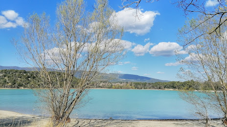
Étang de la Bonde on the map, Pertuis, France
Photo
Where is located Étang de la Bonde
Étang de la Bonde — local attraction, which is located at 30 ha and belongs to the category — -. Average visitor rating for this place — 4.3 (according to 302 ratings, information from open sources and relevant for 2022).
Exact location — Étang de la Bonde, marked on the map with a red marker.
You can get directions to Étang de la Bonde on the map from your location.
What else is interesting in Pertuis? You can see all the sights if you go to the city page.
Coordinates
Étang de la Bonde, France coordinates in decimal format: latitude — 43.76122827847888, longitude — 5.50637384621711. When converted to degrees, minutes, seconds Étang de la Bonde has the following coordinates: 43°45′40.42 north latitude and 5°30′22.95 east longitude.
Nearby cities
The largest cities that are located nearby:
- Aix-en-Provence — 19 km
- Marseille — 45 km
- Toulon — 72 km
- Nimes — 92 km
- Montpellier — 130 km
- Nice — 141 km
- Grenoble — 166 km
- Saint-Étienne — 211 km
- Turin
 (Italy) — 229 km
 - Villeurbanne — 234 km
- Lyon — 235 km
- Perpignan — 239 km
- Geneva
 (Switzerland) — 281 km
 - Genoa (Italy) — 283 km
- Clermont-Ferrand — 296 km
- Novara (Italy) — 310 km
- Lausanne (Switzerland) — 324 km
- Toulouse — 325 km
- Milan (Italy) — 346 km
Distance to the capital
Distance to the capital (Paris) is about — 616 km.