
 Maureville
Samoëns
Gréning
Toulouse
Volx
Goudet
Méhoncourt
Saint-Hymer
Pontcarré
Maureville
Samoëns
Gréning
Toulouse
Volx
Goudet
Méhoncourt
Saint-Hymer
Pontcarré
Plage de la Grande-Conche on the map, Royan, France
Photo
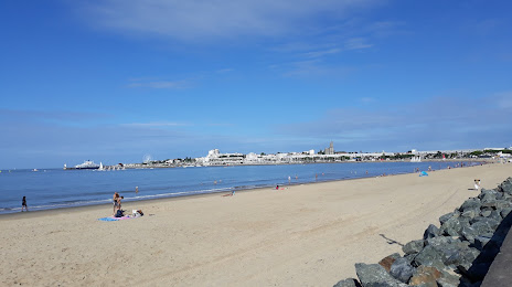
Where is located Plage de la Grande-Conche
Plage de la Grande-Conche — local attraction, which is located at no data and belongs to the category — -. Average visitor rating for this place — 4.4 (according to 771 rating, information from open sources and relevant for 2022).
Exact location — Plage de la Grande-Conche, marked on the map with a red marker.
You can get directions to Plage de la Grande-Conche on the map from your location.
What else is interesting in Royan? You can see all the sights if you go to the city page.
Coordinates
Plage de la Grande-Conche, France coordinates in decimal format: latitude — 45.61497868356881, longitude — -1.018422922114789. When converted to degrees, minutes, seconds Plage de la Grande-Conche has the following coordinates: 45°36′53.92 north latitude and -1°1′6.32 east longitude.
Nearby cities
The largest cities that are located nearby:
- Bordeaux — 94 km
- Limoges — 179 km
- Nantes — 181 km
- Angers — 208 km
- Tours — 235 km
- San Sebastián
 (Spain) — 266 km
 - Le Mans — 279 km
- Rennes — 280 km
- Toulouse — 299 km
- Bilbao (Spain) — 302 km
- Pamplona (Spain) — 315 km
- Clermont-Ferrand — 319 km
- Santander (Spain) — 326 km
- Vitoria-Gasteiz (Spain) — 333 km
- Orléans — 334 km
- Logroño (Spain) — 368 km
- Caen — 397 km
- Brest — 397 km
- Saint-Étienne — 422 km
Distance to the capital
Distance to the capital (Paris) is about — 441 km.