
 Maureville
Samoëns
Gréning
Toulouse
Volx
Goudet
Méhoncourt
Saint-Hymer
Pontcarré
Maureville
Samoëns
Gréning
Toulouse
Volx
Goudet
Méhoncourt
Saint-Hymer
Pontcarré
Château de la Rongère on the map, Château-Gontier, France
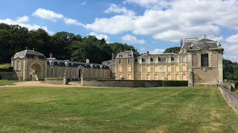
Photo
Where is located Château de la Rongère
Château de la Rongère — local attraction, which is located at Le Bourg, 53360 La Roche-Neuville, France and belongs to the category — castle. Average visitor rating for this place — 4.4 (according to 14 ratings, information from open sources and relevant for 2022).
Exact location — Château de la Rongère, marked on the map with a red marker.
You can get directions to Château de la Rongère on the map from your location.
What else is interesting in Château-Gontier? You can see all the sights if you go to the city page.
Coordinates
Château de la Rongère, France coordinates in decimal format: latitude — 47.90098281179283, longitude — -0.7161610748098314. When converted to degrees, minutes, seconds Château de la Rongère has the following coordinates: 47°54′3.54 north latitude and -0°42′58.18 east longitude.
Nearby cities
The largest cities that are located nearby:
- Angers — 40 km
- Le Mans — 70 km
- Rennes — 79 km
- Nantes — 93 km
- Tours — 115 km
- Caen — 152 km
- Le Havre — 193 km
- Orléans — 194 km
- Rouen — 221 km
- Boulogne-Billancourt — 242 km
- Limoges — 267 km
- Brest — 284 km
- Amiens — 313 km
- Bournemouth
 (United Kingdom) — 330 km
 - Bordeaux — 331 km
- Portsmouth (United Kingdom) — 332 km
- Eastbourne (United Kingdom) — 333 km
- Southampton (United Kingdom) — 344 km
- Crawley (United Kingdom) — 365 km
Distance to the capital
Distance to the capital (Paris) is about — 250 km.