
 Maureville
Samoëns
Gréning
Toulouse
Volx
Goudet
Méhoncourt
Saint-Hymer
Pontcarré
Maureville
Samoëns
Gréning
Toulouse
Volx
Goudet
Méhoncourt
Saint-Hymer
Pontcarré
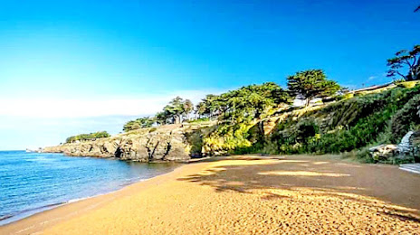
Plage des Sablons on the map, Pornic, France
Photo
Where is located Plage des Sablons
Plage des Sablons — local attraction, which is located at no data and belongs to the category — -. Average visitor rating for this place — 4.4 (according to 732 ratings, information from open sources and relevant for 2022).
Exact location — Plage des Sablons, marked on the map with a red marker.
You can get directions to Plage des Sablons on the map from your location.
What else is interesting in Pornic? You can see all the sights if you go to the city page.
Coordinates
Plage des Sablons, France coordinates in decimal format: latitude — 47.111394252494094, longitude — -2.1377831010578325. When converted to degrees, minutes, seconds Plage des Sablons has the following coordinates: 47°6′41.02 north latitude and -2°8′16.02 east longitude.
Nearby cities
The largest cities that are located nearby:
- Nantes — 43 km
- Rennes — 115 km
- Angers — 122 km
- Le Mans — 197 km
- Tours — 211 km
- Brest — 225 km
- Caen — 261 km
- Bordeaux — 279 km
- Limoges — 295 km
- Le Havre — 307 km
- Orléans — 310 km
- Rouen — 345 km
- Boulogne-Billancourt — 369 km
- Bournemouth
 (United Kingdom) — 399 km
 - Exeter (United Kingdom) — 411 km
- Portsmouth (United Kingdom) — 416 km
- San Sebastián
 (Spain) — 420 km
 - Southampton (United Kingdom) — 422 km
- Santander (Spain) — 426 km
Distance to the capital
Distance to the capital (Paris) is about — 386 km.