
 Maureville
Samoëns
Gréning
Toulouse
Volx
Goudet
Méhoncourt
Saint-Hymer
Pontcarré
Maureville
Samoëns
Gréning
Toulouse
Volx
Goudet
Méhoncourt
Saint-Hymer
Pontcarré
Gardens louanne on the map, Fécamp, France
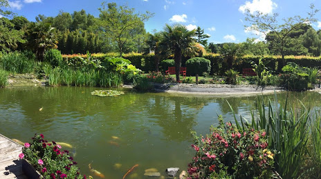
Photo
Where is located Gardens louanne
Gardens louanne — local attraction, which is located at route de Ganzeville, Lieu-dit le Moulin Bleu, 76400 Fécamp, France and belongs to the category — garden. Average visitor rating for this place — 3.6 (according to 148 ratings, information from open sources and relevant for 2022).
Exact location — Gardens louanne, marked on the map with a red marker.
You can get directions to Gardens louanne on the map from your location.
What else is interesting in Fécamp? You can see all the sights if you go to the city page.
Coordinates
Gardens louanne, France coordinates in decimal format: latitude — 49.74644338239571, longitude — 0.40298582525542925. When converted to degrees, minutes, seconds Gardens louanne has the following coordinates: 49°44′47.2 north latitude and 0°24′10.75 east longitude.
Nearby cities
The largest cities that are located nearby:
- Le Havre — 35 km
- Rouen — 62 km
- Caen — 83 km
- Eastbourne
 (United Kingdom) — 112 km
 - Amiens — 137 km
- Crawley (United Kingdom) — 155 km
- Portsmouth (United Kingdom) — 156 km
- Boulogne-Billancourt — 169 km
- Southampton (United Kingdom) — 178 km
- Gillingham (United Kingdom) — 181 km
- Sutton (United Kingdom) — 182 km
- Bournemouth (United Kingdom) — 191 km
- Le Mans — 194 km
- London (United Kingdom) — 197 km
- Southend-on-Sea (United Kingdom) — 199 km
- Basildon (United Kingdom) — 201 km
- Slough (United Kingdom) — 205 km
- Reading (United Kingdom) — 210 km
- Lille — 211 km
Distance to the capital
Distance to the capital (Paris) is about — 173 km.