
 Maureville
Samoëns
Gréning
Toulouse
Volx
Goudet
Méhoncourt
Saint-Hymer
Pontcarré
Maureville
Samoëns
Gréning
Toulouse
Volx
Goudet
Méhoncourt
Saint-Hymer
Pontcarré
Roseraie Saint Anne on the map, Dinard, France
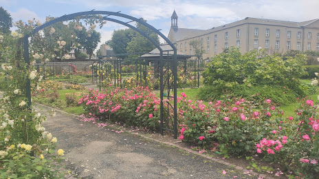
Photo
Where is located Roseraie Saint Anne
Roseraie Saint Anne — local attraction, which is located at 35400 Saint-Malo, France and belongs to the category — park. Average visitor rating for this place — 4.8 (according to 22 ratings, information from open sources and relevant for 2022).
Exact location — Roseraie Saint Anne, marked on the map with a red marker.
You can get directions to Roseraie Saint Anne on the map from your location.
What else is interesting in Dinard? You can see all the sights if you go to the city page.
Coordinates
Roseraie Saint Anne, France coordinates in decimal format: latitude — 48.63332227236467, longitude — -2.015105374784117. When converted to degrees, minutes, seconds Roseraie Saint Anne has the following coordinates: 48°37′59.96 north latitude and -2°0′54.38 east longitude.
Nearby cities
The largest cities that are located nearby:
- Rennes — 63 km
- Caen — 136 km
- Nantes — 161 km
- Angers — 169 km
- Brest — 180 km
- Le Mans — 181 km
- Le Havre — 182 km
- Bournemouth
 (United Kingdom) — 231 km
 - Rouen — 244 km
- Tours — 247 km
- Portsmouth (United Kingdom) — 251 km
- Exeter (United Kingdom) — 253 km
- Southampton (United Kingdom) — 256 km
- Eastbourne (United Kingdom) — 287 km
- Crawley (United Kingdom) — 303 km
- Orléans — 305 km
- Boulogne-Billancourt — 313 km
- Bristol (Great Britain) — 314 km
- Reading (United Kingdom) — 321 km
Distance to the capital
Distance to the capital (Paris) is about — 321 km.