
 Maureville
Samoëns
Gréning
Toulouse
Volx
Goudet
Méhoncourt
Saint-Hymer
Pontcarré
Maureville
Samoëns
Gréning
Toulouse
Volx
Goudet
Méhoncourt
Saint-Hymer
Pontcarré
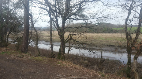
The Pond Of The Goden (L Etang De La Goden) on the map, Lanester, France
Photo
Where is located The Pond Of The Goden (L Etang De La Goden)
The Pond Of The Goden (L Etang De La Goden) — local attraction, which is located at 3 Pont du Bouc, 56600 Lanester, France and belongs to the category — hiking area. Average visitor rating for this place — 4.4 (according to 79 ratings, information from open sources and relevant for 2022).
Exact location — The Pond Of The Goden (L Etang De La Goden), marked on the map with a red marker.
You can get directions to The Pond Of The Goden (L Etang De La Goden) on the map from your location.
What else is interesting in Lanester? You can see all the sights if you go to the city page.
Coordinates
The Pond Of The Goden (L Etang De La Goden), France coordinates in decimal format: latitude — 47.76632392767999, longitude — -3.3268366748145177. When converted to degrees, minutes, seconds The Pond Of The Goden (L Etang De La Goden) has the following coordinates: 47°45′58.77 north latitude and -3°19′36.61 east longitude.
Nearby cities
The largest cities that are located nearby:
- Brest — 109 km
- Rennes — 129 km
- Nantes — 148 km
- Angers — 210 km
- Le Mans — 264 km
- Caen — 266 km
- Tours — 305 km
- Le Havre — 313 km
- Exeter
 (United Kingdom) — 327 km
 - Bournemouth (United Kingdom) — 343 km
- Rouen — 370 km
- Portsmouth (United Kingdom) — 373 km
- Southampton (United Kingdom) — 373 km
- Bordeaux — 390 km
- Orléans — 390 km
- Bristol (Great Britain) — 411 km
- Limoges — 414 km
- Eastbourne (United Kingdom) — 418 km
- Boulogne-Billancourt — 424 km
Distance to the capital
Distance to the capital (Paris) is about — 437 km.