
 Maureville
Samoëns
Gréning
Toulouse
Volx
Goudet
Méhoncourt
Saint-Hymer
Pontcarré
Maureville
Samoëns
Gréning
Toulouse
Volx
Goudet
Méhoncourt
Saint-Hymer
Pontcarré
Viaduc des Fauvettes on the map, Les Ulis, France
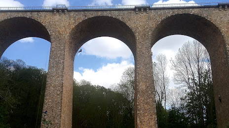
Photo
Where is located Viaduc des Fauvettes
Viaduc des Fauvettes — local attraction, which is located at 91940 Gometz-le-Châtel, France and belongs to the category — tourist attraction. Average visitor rating for this place — 4.6 (according to 421 rating, information from open sources and relevant for 2022).
Exact location — Viaduc des Fauvettes, marked on the map with a red marker.
You can get directions to Viaduc des Fauvettes on the map from your location.
What else is interesting in Les Ulis? You can see all the sights if you go to the city page.
Coordinates
Viaduc des Fauvettes, France coordinates in decimal format: latitude — 48.678671101057425, longitude — 2.1525076252174693. When converted to degrees, minutes, seconds Viaduc des Fauvettes has the following coordinates: 48°40′43.22 north latitude and 2°9′9.03 east longitude.
Nearby cities
The largest cities that are located nearby:
- Boulogne-Billancourt — 19 km
- Orléans — 88 km
- Rouen — 114 km
- Amiens — 135 km
- Reims — 149 km
- Le Mans — 163 km
- Le Havre — 173 km
- Tours — 180 km
- Caen — 192 km
- Lille — 224 km
- Angers — 243 km
- Charleroi
 (Belgium) — 250 km
 - Dijon — 263 km
- Eastbourne
 (United Kingdom) — 266 km
 - Namur (Belgium) — 274 km
- Brussels (Belgium) — 284 km
- Rennes — 290 km
- Nancy — 293 km
- Metz — 294 km
Distance to the capital
Distance to the capital (Paris) is about — 25 km.