
 Maureville
Samoëns
Gréning
Toulouse
Volx
Goudet
Méhoncourt
Saint-Hymer
Pontcarré
Maureville
Samoëns
Gréning
Toulouse
Volx
Goudet
Méhoncourt
Saint-Hymer
Pontcarré
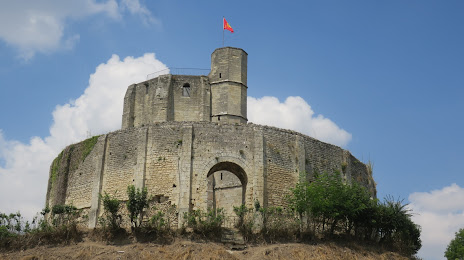
Castillo de Gisors on the map, Gisors, France
Photo
Where is located Castillo de Gisors
Castillo de Gisors — local attraction, which is located at Pl. de Blanmont, 27140 Gisors, France and belongs to the category — castle. Average visitor rating for this place — 4.2 (according to 1120 ratings, information from open sources and relevant for 2022).
Exact location — Castillo de Gisors, marked on the map with a red marker.
You can get directions to Castillo de Gisors on the map from your location.
What else is interesting in Gisors? You can see all the sights if you go to the city page.
Coordinates
Castillo de Gisors, France coordinates in decimal format: latitude — 49.28087898397246, longitude — 1.7742877252387892. When converted to degrees, minutes, seconds Castillo de Gisors has the following coordinates: 49°16′51.16 north latitude and 1°46′27.44 east longitude.
Nearby cities
The largest cities that are located nearby:
- Rouen — 52 km
- Boulogne-Billancourt — 59 km
- Amiens — 77 km
- Le Havre — 122 km
- Orléans — 153 km
- Caen — 156 km
- Reims — 163 km
- Lille — 174 km
- Le Mans — 183 km
- Eastbourne
 (United Kingdom) — 195 km
 - Tours — 224 km
- Charleroi
 (Belgium) — 226 km
 - Crawley (United Kingdom) — 244 km
- Gillingham (United Kingdom) — 248 km
- Brussels (Belgium) — 250 km
- Namur (Belgium) — 254 km
- Southend-on-Sea (United Kingdom) — 261 km
- Portsmouth (United Kingdom) — 263 km
- Angers — 265 km
Distance to the capital
Distance to the capital (Paris) is about — 63 km.