
 Maureville
Samoëns
Gréning
Toulouse
Volx
Goudet
Méhoncourt
Saint-Hymer
Pontcarré
Maureville
Samoëns
Gréning
Toulouse
Volx
Goudet
Méhoncourt
Saint-Hymer
Pontcarré
VERTICAL T'AIR PARACHUTISME ARCACHON on the map, Arcachon, France
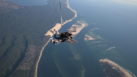
Photo
Where is located VERTICAL T'AIR PARACHUTISME ARCACHON
VERTICAL T'AIR PARACHUTISME ARCACHON — local attraction, which is located at Aérodrome de, Av. de l'Aérodrome, 33260 La Teste-de-Buch, France and belongs to the category — skydiving center. Average visitor rating for this place — 4.8 (according to 506 ratings, information from open sources and relevant for 2022).
Exact location — VERTICAL T'AIR PARACHUTISME ARCACHON, marked on the map with a red marker.
You can get directions to VERTICAL T'AIR PARACHUTISME ARCACHON on the map from your location.
What else is interesting in Arcachon? You can see all the sights if you go to the city page.
Coordinates
VERTICAL T'AIR PARACHUTISME ARCACHON, France coordinates in decimal format: latitude — 44.59876720193337, longitude — -1.1169293749219005. When converted to degrees, minutes, seconds VERTICAL T'AIR PARACHUTISME ARCACHON has the following coordinates: 44°35′55.56 north latitude and -1°7′0.95 east longitude.
Nearby cities
The largest cities that are located nearby:
- Bordeaux — 51 km
- San Sebastián
 (Spain) — 161 km
 - Pamplona (Spain) — 207 km
- Bilbao (Spain) — 209 km
- Limoges — 229 km
- Vitoria-Gasteiz (Spain) — 233 km
- Toulouse — 240 km
- Santander (Spain) — 249 km
- Logroño (Spain) — 263 km
- Nantes — 285 km
- Angers — 316 km
- Burgos (Spain) — 328 km
- Zaragoza (Spain) — 333 km
- Tours — 334 km
- Clermont-Ferrand — 352 km
- Lleida (Spain) — 367 km
- Gijón (Spain) — 380 km
- Le Mans — 385 km
- Rennes — 385 km
Distance to the capital
Distance to the capital (Paris) is about — 542 km.