
 Maureville
Samoëns
Gréning
Toulouse
Volx
Goudet
Méhoncourt
Saint-Hymer
Pontcarré
Maureville
Samoëns
Gréning
Toulouse
Volx
Goudet
Méhoncourt
Saint-Hymer
Pontcarré
Church of Saint Etienne on the map, Bar-le-Duc, France
Photo
Where is located Church of Saint Etienne
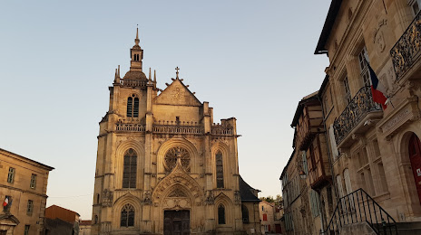
Church of Saint Etienne — local attraction, which is located at Pl. Saint-Pierre, 55000 Bar-le-Duc, France and belongs to the category — church. Average visitor rating for this place — 4.4 (according to 90 ratings, information from open sources and relevant for 2022).
Exact location — Church of Saint Etienne, marked on the map with a red marker.
You can get directions to Church of Saint Etienne on the map from your location.
What else is interesting in Bar-le-Duc? You can see all the sights if you go to the city page.
Coordinates
Church of Saint Etienne, France coordinates in decimal format: latitude — 48.76817455774591, longitude — 5.159325625220614. When converted to degrees, minutes, seconds Church of Saint Etienne has the following coordinates: 48°46′5.43 north latitude and 5°9′33.57 east longitude.
Nearby cities
The largest cities that are located nearby:
- Nancy — 75 km
- Metz — 83 km
- Reims — 97 km
- Saarbrücken
 (Germany) — 142 km
 - Trier (Germany) — 151 km
- Dijon — 161 km
- Besançon — 182 km
- Charleroi
 (Belgium) — 188 km
 - Namur (Belgium) — 188 km
- Strasbourg — 191 km
- Mulhouse — 197 km
- Liège (Belgium) — 208 km
- Boulogne-Billancourt — 212 km
- Freiburg (Germany) — 216 km
- Basel
 (Switzerland) — 226 km
 - Aachen (Germany) — 231 km
- Maastricht
 (Netherlands) — 233 km
 - Brussels (Belgium) — 236 km
- Karlsruhe (Germany) — 237 km
Distance to the capital
Distance to the capital (Paris) is about — 206 km.