
 Maureville
Samoëns
Gréning
Toulouse
Volx
Goudet
Méhoncourt
Saint-Hymer
Pontcarré
Maureville
Samoëns
Gréning
Toulouse
Volx
Goudet
Méhoncourt
Saint-Hymer
Pontcarré
Château de Ville-sur-Saulx on the map, Bar-le-Duc, France
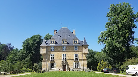
Photo
Where is located Château de Ville-sur-Saulx
Château de Ville-sur-Saulx — local attraction, which is located at 7-9 Route de Lisle 55000, 55000 Ville-sur-Saulx, France and belongs to the category — castle. Average visitor rating for this place — 5.0 (according to 1 rating, information from open sources and relevant for 2022).
Exact location — Château de Ville-sur-Saulx, marked on the map with a red marker.
You can get directions to Château de Ville-sur-Saulx on the map from your location.
What else is interesting in Bar-le-Duc? You can see all the sights if you go to the city page.
Coordinates
Château de Ville-sur-Saulx, France coordinates in decimal format: latitude — 48.71204732218779, longitude — 5.054419925218663. When converted to degrees, minutes, seconds Château de Ville-sur-Saulx has the following coordinates: 48°42′43.37 north latitude and 5°3′15.91 east longitude.
Nearby cities
The largest cities that are located nearby:
- Nancy — 75 km
- Metz — 83 km
- Reims — 97 km
- Saarbrücken
 (Germany) — 142 km
 - Trier (Germany) — 151 km
- Dijon — 161 km
- Besançon — 182 km
- Charleroi
 (Belgium) — 188 km
 - Namur (Belgium) — 188 km
- Strasbourg — 191 km
- Mulhouse — 197 km
- Liège (Belgium) — 208 km
- Boulogne-Billancourt — 212 km
- Freiburg (Germany) — 216 km
- Basel
 (Switzerland) — 226 km
 - Aachen (Germany) — 231 km
- Maastricht
 (Netherlands) — 233 km
 - Brussels (Belgium) — 236 km
- Karlsruhe (Germany) — 237 km
Distance to the capital
Distance to the capital (Paris) is about — 199 km.