
 Maureville
Samoëns
Gréning
Toulouse
Volx
Goudet
Méhoncourt
Saint-Hymer
Pontcarré
Maureville
Samoëns
Gréning
Toulouse
Volx
Goudet
Méhoncourt
Saint-Hymer
Pontcarré
Château de Rosny-sur-Seine on the map, Mantes-la-Jolie, France
Photo
Where is located Château de Rosny-sur-Seine
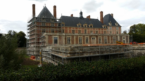
Château de Rosny-sur-Seine — local attraction, which is located at 4B Rue de Guernes, 78710 Rosny-sur-Seine, France and belongs to the category — castle. Average visitor rating for this place — 4.3 (according to 40 ratings, information from open sources and relevant for 2022).
Exact location — Château de Rosny-sur-Seine, marked on the map with a red marker.
You can get directions to Château de Rosny-sur-Seine on the map from your location.
What else is interesting in Mantes-la-Jolie? You can see all the sights if you go to the city page.
Coordinates
Château de Rosny-sur-Seine, France coordinates in decimal format: latitude — 49.00320330697589, longitude — 1.6303315252289265. When converted to degrees, minutes, seconds Château de Rosny-sur-Seine has the following coordinates: 49°0′11.53 north latitude and 1°37′49.19 east longitude.
Nearby cities
The largest cities that are located nearby:
- Boulogne-Billancourt — 42 km
- Rouen — 67 km
- Amiens — 108 km
- Orléans — 121 km
- Le Havre — 128 km
- Caen — 152 km
- Le Mans — 156 km
- Reims — 170 km
- Tours — 192 km
- Lille — 204 km
- Eastbourne
 (United Kingdom) — 220 km
 - Angers — 239 km
- Charleroi
 (Belgium) — 248 km
 - Rennes — 268 km
- Crawley (United Kingdom) — 269 km
- Namur (Belgium) — 276 km
- Brussels (Belgium) — 276 km
- Gillingham (United Kingdom) — 277 km
- Portsmouth (United Kingdom) — 282 km
Distance to the capital
Distance to the capital (Paris) is about — 55 km.