
 Maureville
Samoëns
Gréning
Toulouse
Volx
Goudet
Méhoncourt
Saint-Hymer
Pontcarré
Maureville
Samoëns
Gréning
Toulouse
Volx
Goudet
Méhoncourt
Saint-Hymer
Pontcarré
Rocher de l'imperatrice on the map, Le Relecq-Kerhuon, France
Photo
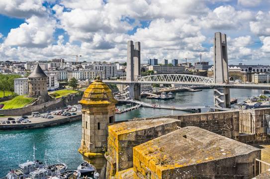
Where is located Rocher de l'imperatrice
Rocher de l'imperatrice — local attraction, which is located at no data and belongs to the category — -. Average visitor rating for this place — 4.4 (according to 46 ratings, information from open sources and relevant for 2022).
Exact location — Rocher de l'imperatrice, marked on the map with a red marker.
You can get directions to Rocher de l'imperatrice on the map from your location.
What else is interesting in Le Relecq-Kerhuon? You can see all the sights if you go to the city page.
Coordinates
Rocher de l'imperatrice, France coordinates in decimal format: latitude — 48.41350609567326, longitude — -4.487390302803789. When converted to degrees, minutes, seconds Rocher de l'imperatrice has the following coordinates: 48°24′48.62 north latitude and -4°29′14.61 east longitude.
Nearby cities
The largest cities that are located nearby:
- Brest — 7 km
- Rennes — 203 km
- Nantes — 250 km
- Exeter
 (United Kingdom) — 263 km
 - Caen — 303 km
- Angers — 304 km
- Bournemouth (United Kingdom) — 310 km
- Le Mans — 343 km
- Le Havre — 345 km
- Southampton (United Kingdom) — 346 km
- Portsmouth (United Kingdom) — 353 km
- Bristol (Great Britain) — 359 km
- Swindon (United Kingdom) — 392 km
- Tours — 396 km
- Reading (United Kingdom) — 411 km
- Rouen — 411 km
- Cheltenham (United Kingdom) — 417 km
- Crawley (United Kingdom) — 418 km
- Eastbourne (United Kingdom) — 419 km
Distance to the capital
Distance to the capital (Paris) is about — 505 km.