
 Maureville
Samoëns
Gréning
Toulouse
Volx
Goudet
Méhoncourt
Saint-Hymer
Pontcarré
Maureville
Samoëns
Gréning
Toulouse
Volx
Goudet
Méhoncourt
Saint-Hymer
Pontcarré
Château de Sainte Assise on the map, Corbeil-Essonnes, France
Photo
Where is located Château de Sainte Assise
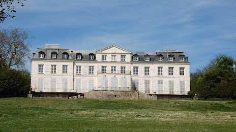
Château de Sainte Assise — local attraction, which is located at Château de Sainte-Assise, 12 château, 77240 Seine-Port, France and belongs to the category — castle. Average visitor rating for this place — 4.5 (according to 10 ratings, information from open sources and relevant for 2022).
Exact location — Château de Sainte Assise, marked on the map with a red marker.
You can get directions to Château de Sainte Assise on the map from your location.
What else is interesting in Corbeil-Essonnes? You can see all the sights if you go to the city page.
Coordinates
Château de Sainte Assise, France coordinates in decimal format: latitude — 48.53914281284031, longitude — 2.5518325252125638. When converted to degrees, minutes, seconds Château de Sainte Assise has the following coordinates: 48°32′20.91 north latitude and 2°33′6.6 east longitude.
Nearby cities
The largest cities that are located nearby:
- Boulogne-Billancourt — 31 km
- Orléans — 89 km
- Reims — 133 km
- Rouen — 135 km
- Amiens — 143 km
- Le Mans — 181 km
- Tours — 190 km
- Le Havre — 196 km
- Caen — 215 km
- Lille — 227 km
- Dijon — 239 km
- Charleroi
 (Belgium) — 243 km
 - Angers — 259 km
- Namur (Belgium) — 266 km
- Nancy — 271 km
- Metz — 274 km
- Brussels (Belgium) — 280 km
- Eastbourne
 (United Kingdom) — 283 km
 - Besançon — 307 km
Distance to the capital
Distance to the capital (Paris) is about — 38 km.