
 Maureville
Samoëns
Gréning
Toulouse
Volx
Goudet
Méhoncourt
Saint-Hymer
Pontcarré
Maureville
Samoëns
Gréning
Toulouse
Volx
Goudet
Méhoncourt
Saint-Hymer
Pontcarré
Pilon du Roi on the map, Plan-de-Cuques, France
Photo
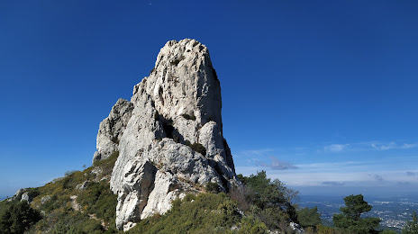
Where is located Pilon du Roi
Pilon du Roi — local attraction, which is located at no data and belongs to the category — -. Average visitor rating for this place — 4.8 (according to 40 ratings, information from open sources and relevant for 2022).
Exact location — Pilon du Roi, marked on the map with a red marker.
You can get directions to Pilon du Roi on the map from your location.
What else is interesting in Plan-de-Cuques? You can see all the sights if you go to the city page.
Coordinates
Pilon du Roi, France coordinates in decimal format: latitude — 43.400827888021844, longitude — 5.464904890971372. When converted to degrees, minutes, seconds Pilon du Roi has the following coordinates: 43°24′2.98 north latitude and 5°27′53.66 east longitude.
Nearby cities
The largest cities that are located nearby:
- Marseille — 9 km
- Aix-en-Provence — 20 km
- Toulon — 45 km
- Nimes — 103 km
- Montpellier — 130 km
- Nice — 149 km
- Grenoble — 205 km
- Perpignan — 221 km
- Saint-Étienne — 246 km
- Turin
 (Italy) — 258 km
 - Lyon — 272 km
- Villeurbanne — 272 km
- Genoa (Italy) — 299 km
- Geneva
 (Switzerland) — 320 km
 - Mataró
 (Spain) — 320 km
 - Toulouse — 323 km
- Clermont-Ferrand — 325 km
- Novara (Italy) — 338 km
- Badalona (Spain) — 339 km
Distance to the capital
Distance to the capital (Paris) is about — 652 km.