
 Maureville
Samoëns
Gréning
Toulouse
Volx
Goudet
Méhoncourt
Saint-Hymer
Pontcarré
Maureville
Samoëns
Gréning
Toulouse
Volx
Goudet
Méhoncourt
Saint-Hymer
Pontcarré
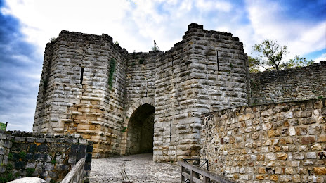
Chateau-Thierry castle on the map, Château-Thierry, France
Photo
Where is located Chateau-Thierry castle
Chateau-Thierry castle — local attraction, which is located at 16 Pl. de l'Hôtel de ville, 02400 Château-Thierry, France and belongs to the category — tourist attraction. Average visitor rating for this place — 4.4 (according to 300 ratings, information from open sources and relevant for 2022).
Exact location — Chateau-Thierry castle, marked on the map with a red marker.
You can get directions to Chateau-Thierry castle on the map from your location.
What else is interesting in Château-Thierry? You can see all the sights if you go to the city page.
Coordinates
Chateau-Thierry castle, France coordinates in decimal format: latitude — 49.04701743485454, longitude — 3.4021199252304943. When converted to degrees, minutes, seconds Chateau-Thierry castle has the following coordinates: 49°2′49.26 north latitude and 3°24′7.63 east longitude.
Nearby cities
The largest cities that are located nearby:
- Reims — 51 km
- Boulogne-Billancourt — 88 km
- Amiens — 123 km
- Charleroi
 (Belgium) — 168 km
 - Orléans — 168 km
- Rouen — 171 km
- Lille — 177 km
- Namur (Belgium) — 188 km
- Metz — 201 km
- Nancy — 207 km
- Brussels (Belgium) — 210 km
- Dijon — 227 km
- Liège (Belgium) — 233 km
- Le Havre — 242 km
- Trier
 (Germany) — 244 km
 - Antwerp (Belgium) — 250 km
- Maastricht
 (Netherlands) — 256 km
 - Saarbrücken (Germany) — 260 km
- Le Mans — 263 km
Distance to the capital
Distance to the capital (Paris) is about — 80 km.