
 Maureville
Samoëns
Gréning
Toulouse
Volx
Goudet
Méhoncourt
Saint-Hymer
Pontcarré
Maureville
Samoëns
Gréning
Toulouse
Volx
Goudet
Méhoncourt
Saint-Hymer
Pontcarré
Parc des Perrières on the map, Brive-la-Gaillarde, France
Photo
Where is located Parc des Perrières
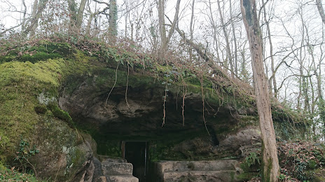
Parc des Perrières — local attraction, which is located at Imp. Raoul Desvignes, 19100 Brive-la-Gaillarde, France and belongs to the category — park. Average visitor rating for this place — 4.3 (according to 193 ratings, information from open sources and relevant for 2022).
Exact location — Parc des Perrières, marked on the map with a red marker.
You can get directions to Parc des Perrières on the map from your location.
What else is interesting in Brive-la-Gaillarde? You can see all the sights if you go to the city page.
Coordinates
Parc des Perrières, France coordinates in decimal format: latitude — 45.14841892870997, longitude — 1.520063525096315. When converted to degrees, minutes, seconds Parc des Perrières has the following coordinates: 45°8′54.31 north latitude and 1°31′12.23 east longitude.
Nearby cities
The largest cities that are located nearby:
- Limoges — 77 km
- Clermont-Ferrand — 138 km
- Bordeaux — 169 km
- Toulouse — 172 km
- Saint-Étienne — 224 km
- Montpellier — 254 km
- Tours — 255 km
- Lyon — 263 km
- Villeurbanne — 268 km
- Nimes — 269 km
- Perpignan — 295 km
- Angers — 300 km
- Orléans — 305 km
- Nantes — 325 km
- Grenoble — 327 km
- Le Mans — 330 km
- San Sebastián
 (Spain) — 348 km
 - Dijon — 355 km
- Aix-en-Provence — 362 km
Distance to the capital
Distance to the capital (Paris) is about — 417 km.