
 Maureville
Samoëns
Gréning
Toulouse
Volx
Goudet
Méhoncourt
Saint-Hymer
Pontcarré
Maureville
Samoëns
Gréning
Toulouse
Volx
Goudet
Méhoncourt
Saint-Hymer
Pontcarré
Haut de Cagnes on the map, Cagnes-sur-Mer, France
Photo
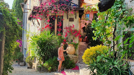
Where is located Haut de Cagnes
Haut de Cagnes — local attraction, which is located at Le haut de, Cagnes-sur-Mer, France and belongs to the category — museum. Average visitor rating for this place — 5.0 (according to 4 ratings, information from open sources and relevant for 2022).
Exact location — Haut de Cagnes, marked on the map with a red marker.
You can get directions to Haut de Cagnes on the map from your location.
What else is interesting in Cagnes-sur-Mer? You can see all the sights if you go to the city page.
Coordinates
Haut de Cagnes, France coordinates in decimal format: latitude — 43.688533823473094, longitude — 7.1439448915710635. When converted to degrees, minutes, seconds Haut de Cagnes has the following coordinates: 43°41′18.72 north latitude and 7°8′38.2 east longitude.
Nearby cities
The largest cities that are located nearby:
- Nice — 10 km
- Toulon — 115 km
- Aix-en-Provence — 137 km
- Marseille — 149 km
- Turin
 (Italy) — 161 km
 - Genoa (Italy) — 164 km
- Grenoble — 202 km
- Nimes — 223 km
- Novara (Italy) — 228 km
- Livorno (Italy) — 254 km
- Milan (Italy) — 254 km
- Montpellier — 262 km
- Monza (Italy) — 269 km
- Parma (Italy) — 279 km
- Saint-Étienne — 291 km
- Geneva
 (Switzerland) — 291 km
 - Villeurbanne — 291 km
- Lyon — 293 km
- Bergamo (Italy) — 298 km
Distance to the capital
Distance to the capital (Paris) is about — 682 km.