
 Maureville
Samoëns
Gréning
Toulouse
Volx
Goudet
Méhoncourt
Saint-Hymer
Pontcarré
Maureville
Samoëns
Gréning
Toulouse
Volx
Goudet
Méhoncourt
Saint-Hymer
Pontcarré
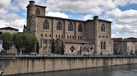
Collégiale Saint-Barnard on the map, Romans-sur-Isère, France
Photo
Where is located Collégiale Saint-Barnard
Collégiale Saint-Barnard — local attraction, which is located at 3 Pl. Maurice Faure, 26100 Romans-sur-Isère, France and belongs to the category — catholic church. Average visitor rating for this place — 4.4 (according to 122 ratings, information from open sources and relevant for 2022).
Exact location — Collégiale Saint-Barnard, marked on the map with a red marker.
You can get directions to Collégiale Saint-Barnard on the map from your location.
What else is interesting in Romans-sur-Isère? You can see all the sights if you go to the city page.
Coordinates
Collégiale Saint-Barnard, France coordinates in decimal format: latitude — 45.042487665486924, longitude — 5.048867425092817. When converted to degrees, minutes, seconds Collégiale Saint-Barnard has the following coordinates: 45°2′32.96 north latitude and 5°2′55.92 east longitude.
Nearby cities
The largest cities that are located nearby:
- Grenoble — 55 km
- Saint-Étienne — 68 km
- Lyon — 81 km
- Villeurbanne — 81 km
- Nimes — 144 km
- Geneva
 (Switzerland) — 152 km
 - Aix-en-Provence — 170 km
- Clermont-Ferrand — 172 km
- Montpellier — 184 km
- Marseille — 195 km
- Lausanne (Switzerland) — 203 km
- Turin
 (Italy) — 206 km
 - Toulon — 224 km
- Nice — 230 km
- Dijon — 252 km
- Besançon — 253 km
- Bern (Switzerland) — 277 km
- Novara (Italy) — 280 km
- Limoges — 305 km
Distance to the capital
Distance to the capital (Paris) is about — 471 km.