
 Maureville
Samoëns
Gréning
Toulouse
Volx
Goudet
Méhoncourt
Saint-Hymer
Pontcarré
Maureville
Samoëns
Gréning
Toulouse
Volx
Goudet
Méhoncourt
Saint-Hymer
Pontcarré
Flumen on the map, Saint-Claude, France
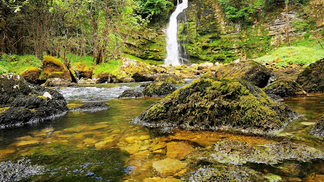
Photo
Where is located Flumen
Flumen — local attraction, which is located at Le Tacon and belongs to the category — -. Average visitor rating for this place — 4.7 (according to 16 ratings, information from open sources and relevant for 2022).
Exact location — Flumen, marked on the map with a red marker.
You can get directions to Flumen on the map from your location.
What else is interesting in Saint-Claude? You can see all the sights if you go to the city page.
Coordinates
Flumen, France coordinates in decimal format: latitude — 46.36033511352224, longitude — 5.889865197288047. When converted to degrees, minutes, seconds Flumen has the following coordinates: 46°21′37.21 north latitude and 5°53′23.51 east longitude.
Nearby cities
The largest cities that are located nearby:
- Geneva
 (Switzerland) — 30 km
 - Lausanne (Switzerland) — 60 km
- Besançon — 95 km
- Villeurbanne — 102 km
- Lyon — 105 km
- Dijon — 120 km
- Grenoble — 133 km
- Bern (Switzerland) — 134 km
- Saint-Étienne — 155 km
- Basel (Switzerland) — 184 km
- Mulhouse — 186 km
- Turin
 (Italy) — 203 km
 - Clermont-Ferrand — 225 km
- Zurich (Switzerland) — 228 km
- Freiburg
 (Germany) — 230 km
 - Novara (Italy) — 238 km
- Nancy — 256 km
- Milan (Italy) — 277 km
- Monza (Italy) — 278 km
Distance to the capital
Distance to the capital (Paris) is about — 384 km.