
 Maureville
Samoëns
Gréning
Toulouse
Volx
Goudet
Méhoncourt
Saint-Hymer
Pontcarré
Maureville
Samoëns
Gréning
Toulouse
Volx
Goudet
Méhoncourt
Saint-Hymer
Pontcarré
Parc de Bécon on the map, Bois-Colombes, France
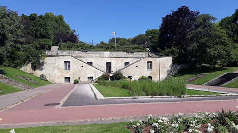
Photo
Where is located Parc de Bécon
Parc de Bécon — local attraction, which is located at 156 Bd Saint-Denis, 92400 Courbevoie, France and belongs to the category — park. Average visitor rating for this place — 4.2 (according to 1411 ratings, information from open sources and relevant for 2022).
Exact location — Parc de Bécon, marked on the map with a red marker.
You can get directions to Parc de Bécon on the map from your location.
What else is interesting in Bois-Colombes? You can see all the sights if you go to the city page.
Coordinates
Parc de Bécon, France coordinates in decimal format: latitude — 48.89973484121326, longitude — 2.2701152252252617. When converted to degrees, minutes, seconds Parc de Bécon has the following coordinates: 48°53′59.05 north latitude and 2°16′12.41 east longitude.
Nearby cities
The largest cities that are located nearby:
- Boulogne-Billancourt — 9 km
- Rouen — 102 km
- Amiens — 108 km
- Orléans — 115 km
- Reims — 133 km
- Le Havre — 168 km
- Le Mans — 183 km
- Caen — 193 km
- Lille — 197 km
- Tours — 206 km
- Charleroi
 (Belgium) — 225 km
 - Eastbourne
 (United Kingdom) — 247 km
 - Namur (Belgium) — 251 km
- Brussels (Belgium) — 258 km
- Angers — 265 km
- Dijon — 273 km
- Metz — 284 km
- Nancy — 287 km
- Antwerp (Belgium) — 294 km
Distance to the capital
Distance to the capital (Paris) is about — 8 km.