
 Maureville
Samoëns
Gréning
Toulouse
Volx
Goudet
Méhoncourt
Saint-Hymer
Pontcarré
Maureville
Samoëns
Gréning
Toulouse
Volx
Goudet
Méhoncourt
Saint-Hymer
Pontcarré
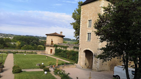
Château de Saint Bernard on the map, Villefranche-sur-Saone, France
Photo
Where is located Château de Saint Bernard
Château de Saint Bernard — local attraction, which is located at 152 Av. Suzanne Valadon, 01600 Saint-Bernard, France and belongs to the category — castle. Average visitor rating for this place — 4.4 (according to 131 rating, information from open sources and relevant for 2022).
Exact location — Château de Saint Bernard, marked on the map with a red marker.
You can get directions to Château de Saint Bernard on the map from your location.
What else is interesting in Villefranche-sur-Saone? You can see all the sights if you go to the city page.
Coordinates
Château de Saint Bernard, France coordinates in decimal format: latitude — 45.944501607555004, longitude — 4.732918725123031. When converted to degrees, minutes, seconds Château de Saint Bernard has the following coordinates: 45°56′40.21 north latitude and 4°43′58.51 east longitude.
Nearby cities
The largest cities that are located nearby:
- Lyon — 27 km
- Villeurbanne — 28 km
- Saint-Étienne — 66 km
- Geneva
 (Switzerland) — 111 km
 - Grenoble — 118 km
- Clermont-Ferrand — 128 km
- Dijon — 149 km
- Lausanne (Switzerland) — 157 km
- Besançon — 169 km
- Bern (Switzerland) — 231 km
- Nimes — 240 km
- Turin
 (Italy) — 253 km
 - Limoges — 267 km
- Montpellier — 272 km
- Mulhouse — 275 km
- Basel (Switzerland) — 277 km
- Aix-en-Provence — 278 km
- Orléans — 297 km
- Marseille — 303 km
Distance to the capital
Distance to the capital (Paris) is about — 370 km.