
 Maureville
Samoëns
Gréning
Toulouse
Volx
Goudet
Méhoncourt
Saint-Hymer
Pontcarré
Maureville
Samoëns
Gréning
Toulouse
Volx
Goudet
Méhoncourt
Saint-Hymer
Pontcarré
Loisinord Stade de Glisse on the map, Nœux-les-Mines, France
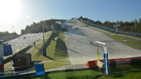
Photo
Where is located Loisinord Stade de Glisse
Loisinord Stade de Glisse — local attraction, which is located at Av. du Lac, 62290 Nœux-les-Mines, France and belongs to the category — ski resort. Average visitor rating for this place — 4.2 (according to 557 ratings, information from open sources and relevant for 2022).
Exact location — Loisinord Stade de Glisse, marked on the map with a red marker.
You can get directions to Loisinord Stade de Glisse on the map from your location.
What else is interesting in Nœux-les-Mines? You can see all the sights if you go to the city page.
Coordinates
Loisinord Stade de Glisse, France coordinates in decimal format: latitude — 50.47215195168038, longitude — 2.679172725281577. When converted to degrees, minutes, seconds Loisinord Stade de Glisse has the following coordinates: 50°28′19.75 north latitude and 2°40′45.02 east longitude.
Nearby cities
The largest cities that are located nearby:
- Lille — 32 km
- Amiens — 70 km
- Brussels
 (Belgium) — 125 km
 - Charleroi (Belgium) — 126 km
- Antwerp (Belgium) — 146 km
- Namur (Belgium) — 156 km
- Rouen — 161 km
- Reims — 167 km
- Eastbourne
 (United Kingdom) — 169 km
 - Gillingham (United Kingdom) — 177 km
- Southend-on-Sea (United Kingdom) — 179 km
- Boulogne-Billancourt — 184 km
- Breda
 (Netherlands) — 190 km
 - Basildon (United Kingdom) — 192 km
- Rotterdam (Netherlands) — 202 km
- Dordrecht (Netherlands) — 202 km
- Ipswich (United Kingdom) — 202 km
- Chelmsford (United Kingdom) — 204 km
- Tilburg (Netherlands) — 205 km
Distance to the capital
Distance to the capital (Paris) is about — 181 km.