
 Maureville
Samoëns
Gréning
Toulouse
Volx
Goudet
Méhoncourt
Saint-Hymer
Pontcarré
Maureville
Samoëns
Gréning
Toulouse
Volx
Goudet
Méhoncourt
Saint-Hymer
Pontcarré
Château de Cabriès on the map, Bouc-Bel-Air, France
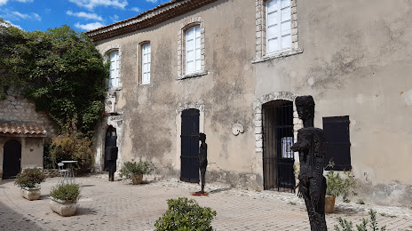
Photo
Where is located Château de Cabriès
Château de Cabriès — local attraction, which is located at Château de Cabriès, 13480 Cabriès, France and belongs to the category — art museum. Average visitor rating for this place — 4.2 (according to 38 ratings, information from open sources and relevant for 2022).
Exact location — Château de Cabriès, marked on the map with a red marker.
You can get directions to Château de Cabriès on the map from your location.
What else is interesting in Bouc-Bel-Air? You can see all the sights if you go to the city page.
Coordinates
Château de Cabriès, France coordinates in decimal format: latitude — 43.44108272408222, longitude — 5.379598525040313. When converted to degrees, minutes, seconds Château de Cabriès has the following coordinates: 43°26′27.9 north latitude and 5°22′46.55 east longitude.
Nearby cities
The largest cities that are located nearby:
- Aix-en-Provence — 9 km
- Marseille — 17 km
- Toulon — 55 km
- Nimes — 94 km
- Montpellier — 124 km
- Nice — 150 km
- Grenoble — 194 km
- Perpignan — 221 km
- Saint-Étienne — 234 km
- Turin
 (Italy) — 252 km
 - Lyon — 260 km
- Villeurbanne — 260 km
- Genoa (Italy) — 298 km
- Geneva
 (Switzerland) — 309 km
 - Clermont-Ferrand — 314 km
- Toulouse — 318 km
- Mataró
 (Spain) — 324 km
 - Novara (Italy) — 333 km
- Badalona (Spain) — 344 km
Distance to the capital
Distance to the capital (Paris) is about — 646 km.