
 Maureville
Samoëns
Gréning
Toulouse
Volx
Goudet
Méhoncourt
Saint-Hymer
Pontcarré
Maureville
Samoëns
Gréning
Toulouse
Volx
Goudet
Méhoncourt
Saint-Hymer
Pontcarré
Palais des Papes on the map, Villeneuve-lès-Avignon, France
Photo
Where is located Palais des Papes
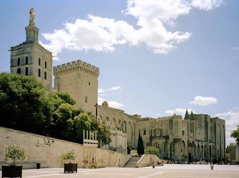
Palais des Papes — local attraction, which is located at Pl. du Palais, 84000 Avignon, France and belongs to the category — palace. Average visitor rating for this place — 4.5 (according to 29610 ratings, information from open sources and relevant for 2022).
Exact location — Palais des Papes, marked on the map with a red marker.
You can get directions to Palais des Papes on the map from your location.
What else is interesting in Villeneuve-lès-Avignon? You can see all the sights if you go to the city page.
Coordinates
Palais des Papes, France coordinates in decimal format: latitude — 43.95081732079229, longitude — 4.80763272505686. When converted to degrees, minutes, seconds Palais des Papes has the following coordinates: 43°57′2.94 north latitude and 4°48′27.48 east longitude.
Nearby cities
The largest cities that are located nearby:
- Nimes — 38 km
- Aix-en-Provence — 71 km
- Montpellier — 83 km
- Marseille — 87 km
- Toulon — 130 km
- Grenoble — 154 km
- Saint-Étienne — 166 km
- Nice — 199 km
- Lyon — 199 km
- Villeurbanne — 200 km
- Perpignan — 209 km
- Clermont-Ferrand — 240 km
- Turin
 (Italy) — 257 km
 - Geneva
 (Switzerland) — 268 km
 - Toulouse — 271 km
- Lausanne (Switzerland) — 315 km
- Mataró
 (Spain) — 331 km
 - Genoa (Italy) — 331 km
- Novara (Italy) — 339 km
Distance to the capital
Distance to the capital (Paris) is about — 577 km.