
 Maureville
Samoëns
Gréning
Toulouse
Volx
Goudet
Méhoncourt
Saint-Hymer
Pontcarré
Maureville
Samoëns
Gréning
Toulouse
Volx
Goudet
Méhoncourt
Saint-Hymer
Pontcarré
VERTICAL T'AIR PARACHUTISME ARCACHON on the map, Gujan-Mestras, France
Photo
Where is located VERTICAL T'AIR PARACHUTISME ARCACHON
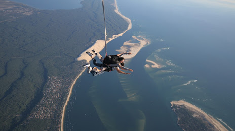
VERTICAL T'AIR PARACHUTISME ARCACHON — local attraction, which is located at Aérodrome de, Av. de l'Aérodrome, 33260 La Teste-de-Buch, France and belongs to the category — skydiving center. Average visitor rating for this place — 4.8 (according to 506 ratings, information from open sources and relevant for 2022).
Exact location — VERTICAL T'AIR PARACHUTISME ARCACHON, marked on the map with a red marker.
You can get directions to VERTICAL T'AIR PARACHUTISME ARCACHON on the map from your location.
What else is interesting in Gujan-Mestras? You can see all the sights if you go to the city page.
Coordinates
VERTICAL T'AIR PARACHUTISME ARCACHON, France coordinates in decimal format: latitude — 44.59876720193337, longitude — -1.1169293749219005. When converted to degrees, minutes, seconds VERTICAL T'AIR PARACHUTISME ARCACHON has the following coordinates: 44°35′55.56 north latitude and -1°7′0.95 east longitude.
Nearby cities
The largest cities that are located nearby:
- Bordeaux — 45 km
- San Sebastián
 (Spain) — 163 km
 - Pamplona (Spain) — 207 km
- Bilbao (Spain) — 213 km
- Limoges — 223 km
- Toulouse — 231 km
- Vitoria-Gasteiz (Spain) — 236 km
- Santander (Spain) — 255 km
- Logroño (Spain) — 265 km
- Nantes — 288 km
- Angers — 317 km
- Zaragoza (Spain) — 331 km
- Burgos (Spain) — 332 km
- Tours — 332 km
- Clermont-Ferrand — 345 km
- Lleida (Spain) — 362 km
- Le Mans — 384 km
- Rennes — 388 km
- Perpignan — 388 km
Distance to the capital
Distance to the capital (Paris) is about — 542 km.