
 Maureville
Samoëns
Gréning
Toulouse
Volx
Goudet
Méhoncourt
Saint-Hymer
Pontcarré
Maureville
Samoëns
Gréning
Toulouse
Volx
Goudet
Méhoncourt
Saint-Hymer
Pontcarré
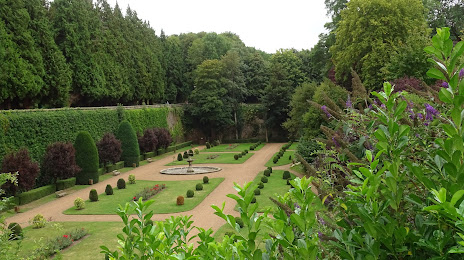
De Saint-Omer Public Garden (Jardin Public de Saint-Omer) on the map, Saint-Omer, France
Photo
Where is located De Saint-Omer Public Garden (Jardin Public de Saint-Omer)
De Saint-Omer Public Garden (Jardin Public de Saint-Omer) — local attraction, which is located at All. du Parc, 62500 Saint-Omer, France and belongs to the category — garden. Average visitor rating for this place — 4.5 (according to 2774 ratings, information from open sources and relevant for 2022).
Exact location — de Saint-Omer Public Garden (Jardin Public de Saint-Omer), marked on the map with a red marker.
You can get directions to De Saint-Omer Public Garden (Jardin Public de Saint-Omer) on the map from your location.
What else is interesting in Saint-Omer? You can see all the sights if you go to the city page.
Coordinates
de Saint-Omer Public Garden (Jardin Public de Saint-Omer), France coordinates in decimal format: latitude — 50.74876363185861, longitude — 2.2475929252916336. When converted to degrees, minutes, seconds de Saint-Omer Public Garden (Jardin Public de Saint-Omer) has the following coordinates: 50°44′55.55 north latitude and 2°14′51.33 east longitude.
Nearby cities
The largest cities that are located nearby:
- Lille — 58 km
- Amiens — 95 km
- Gillingham
 (United Kingdom) — 137 km
 - Eastbourne (United Kingdom) — 137 km
- Southend-on-Sea (United Kingdom) — 138 km
- Brussels
 (Belgium) — 147 km
 - Basildon (United Kingdom) — 152 km
- Antwerp (Belgium) — 158 km
- Charleroi (Belgium) — 159 km
- Ipswich (United Kingdom) — 163 km
- Chelmsford (United Kingdom) — 164 km
- Rouen — 167 km
- Crawley (United Kingdom) — 174 km
- Sutton (United Kingdom) — 182 km
- London (United Kingdom) — 184 km
- Namur (Belgium) — 187 km
- Breda
 (Netherlands) — 196 km
 - Rotterdam (Netherlands) — 200 km
- The Hague (Netherlands) — 202 km
Distance to the capital
Distance to the capital (Paris) is about — 211 km.