
 Maureville
Samoëns
Gréning
Toulouse
Volx
Goudet
Méhoncourt
Saint-Hymer
Pontcarré
Maureville
Samoëns
Gréning
Toulouse
Volx
Goudet
Méhoncourt
Saint-Hymer
Pontcarré
Château de Montaigu on the map, Vandœuvre-lès-Nancy, France
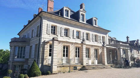
Photo
Where is located Château de Montaigu
Château de Montaigu — local attraction, which is located at Rue de l'Ermitage, 54140 Laneuveville-devant-Nancy, France and belongs to the category — castle. Average visitor rating for this place — 4.4 (according to 395 ratings, information from open sources and relevant for 2022).
Exact location — Château de Montaigu, marked on the map with a red marker.
You can get directions to Château de Montaigu on the map from your location.
What else is interesting in Vandœuvre-lès-Nancy? You can see all the sights if you go to the city page.
Coordinates
Château de Montaigu, France coordinates in decimal format: latitude — 48.67016439567368, longitude — 6.145929225217155. When converted to degrees, minutes, seconds Château de Montaigu has the following coordinates: 48°40′12.59 north latitude and 6°8′45.35 east longitude.
Nearby cities
The largest cities that are located nearby:
- Nancy — 4 km
- Metz — 51 km
- Saarbrücken
 (Germany) — 87 km
 - Strasbourg — 116 km
- Trier (Germany) — 125 km
- Mulhouse — 133 km
- Freiburg (Germany) — 144 km
- Besançon — 158 km
- Basel
 (Switzerland) — 161 km
 - Karlsruhe (Germany) — 166 km
- Reims — 168 km
- Dijon — 171 km
- Pforzheim (Germany) — 185 km
- Ludwigshafen (Germany) — 186 km
- Mannheim (Germany) — 188 km
- Heidelberg (Germany) — 197 km
- Mainz (Germany) — 208 km
- Bern (Switzerland) — 212 km
- Koblenz (Germany) — 212 km
Distance to the capital
Distance to the capital (Paris) is about — 279 km.