
 Maureville
Samoëns
Gréning
Toulouse
Volx
Goudet
Méhoncourt
Saint-Hymer
Pontcarré
Maureville
Samoëns
Gréning
Toulouse
Volx
Goudet
Méhoncourt
Saint-Hymer
Pontcarré
Le Musée du Travail on the map, Clichy-sous-Bois, France
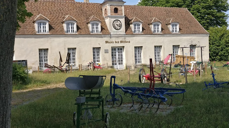
Photo
Where is located Le Musée du Travail
Le Musée du Travail — local attraction, which is located at 1 Rue de l'Église, 93370 Montfermeil, France and belongs to the category — museum. Average visitor rating for this place — 4.7 (according to 16 ratings, information from open sources and relevant for 2022).
Exact location — Le Musée du Travail, marked on the map with a red marker.
You can get directions to Le Musée du Travail on the map from your location.
What else is interesting in Clichy-sous-Bois? You can see all the sights if you go to the city page.
Coordinates
Le Musée du Travail, France coordinates in decimal format: latitude — 48.898432940386556, longitude — 2.563517325225224. When converted to degrees, minutes, seconds Le Musée du Travail has the following coordinates: 48°53′54.36 north latitude and 2°33′48.66 east longitude.
Nearby cities
The largest cities that are located nearby:
- Boulogne-Billancourt — 24 km
- Amiens — 110 km
- Reims — 114 km
- Rouen — 119 km
- Orléans — 121 km
- Le Havre — 187 km
- Lille — 193 km
- Le Mans — 200 km
- Caen — 213 km
- Charleroi
 (Belgium) — 213 km
 - Tours — 218 km
- Namur (Belgium) — 238 km
- Brussels (Belgium) — 249 km
- Dijon — 257 km
- Eastbourne
 (United Kingdom) — 259 km
 - Metz — 264 km
- Nancy — 267 km
- Angers — 281 km
- Liège (Belgium) — 285 km
Distance to the capital
Distance to the capital (Paris) is about — 16 km.