
 Maureville
Samoëns
Gréning
Toulouse
Volx
Goudet
Méhoncourt
Saint-Hymer
Pontcarré
Maureville
Samoëns
Gréning
Toulouse
Volx
Goudet
Méhoncourt
Saint-Hymer
Pontcarré
Fort de la Gavaresse on the map, Le Pradet, France
Photo
Where is located Fort de la Gavaresse
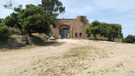
Fort de la Gavaresse — local attraction, which is located at 83220 Le Pradet, France and belongs to the category — fortress. Average visitor rating for this place — 4.7 (according to 34 ratings, information from open sources and relevant for 2022).
Exact location — Fort de la Gavaresse, marked on the map with a red marker.
You can get directions to Fort de la Gavaresse on the map from your location.
What else is interesting in Le Pradet? You can see all the sights if you go to the city page.
Coordinates
Fort de la Gavaresse, France coordinates in decimal format: latitude — 43.08414481796741, longitude — 6.0400893250288075. When converted to degrees, minutes, seconds Fort de la Gavaresse has the following coordinates: 43°5′2.92 north latitude and 6°2′24.32 east longitude.
Nearby cities
The largest cities that are located nearby:
- Toulon — 8 km
- Marseille — 56 km
- Aix-en-Provence — 65 km
- Nice — 120 km
- Nimes — 155 km
- Montpellier — 180 km
- Grenoble — 231 km
- Turin
 (Italy) — 253 km
 - Perpignan — 258 km
- Genoa (Italy) — 272 km
- Saint-Étienne — 287 km
- Villeurbanne — 307 km
- Lyon — 308 km
- Novara (Italy) — 328 km
- Sassari (Italy) — 338 km
- Geneva
 (Switzerland) — 342 km
 - Mataró
 (Spain) — 343 km
 - Livorno (Italy) — 347 km
- Milan (Italy) — 358 km
Distance to the capital
Distance to the capital (Paris) is about — 702 km.