
 Maureville
Samoëns
Gréning
Toulouse
Volx
Goudet
Méhoncourt
Saint-Hymer
Pontcarré
Maureville
Samoëns
Gréning
Toulouse
Volx
Goudet
Méhoncourt
Saint-Hymer
Pontcarré
Plage de Bonne-Source on the map, La Baule-Escoublac, France
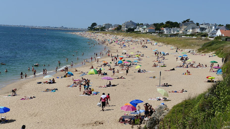
Photo
Where is located Plage de Bonne-Source
Plage de Bonne-Source — local attraction, which is located at no data and belongs to the category — -. Average visitor rating for this place — 4.6 (according to 27 ratings, information from open sources and relevant for 2022).
Exact location — Plage de Bonne-Source, marked on the map with a red marker.
You can get directions to Plage de Bonne-Source on the map from your location.
What else is interesting in La Baule-Escoublac? You can see all the sights if you go to the city page.
Coordinates
Plage de Bonne-Source, France coordinates in decimal format: latitude — 47.24971203691254, longitude — -2.3286406007509983. When converted to degrees, minutes, seconds Plage de Bonne-Source has the following coordinates: 47°14′58.96 north latitude and -2°19′43.11 east longitude.
Nearby cities
The largest cities that are located nearby:
- Nantes — 63 km
- Rennes — 106 km
- Angers — 138 km
- Brest — 196 km
- Le Mans — 208 km
- Tours — 231 km
- Caen — 256 km
- Le Havre — 303 km
- Bordeaux — 306 km
- Limoges — 324 km
- Orléans — 326 km
- Rouen — 346 km
- Boulogne-Billancourt — 378 km
- Bournemouth
 (United Kingdom) — 381 km
 - Exeter (United Kingdom) — 388 km
- Portsmouth (United Kingdom) — 401 km
- Southampton (United Kingdom) — 407 km
- Eastbourne (United Kingdom) — 428 km
- Santander
 (Spain) — 438 km
Distance to the capital
Distance to the capital (Paris) is about — 391 km.