
 Maureville
Samoëns
Gréning
Toulouse
Volx
Goudet
Méhoncourt
Saint-Hymer
Pontcarré
Maureville
Samoëns
Gréning
Toulouse
Volx
Goudet
Méhoncourt
Saint-Hymer
Pontcarré
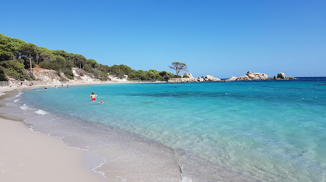
Plage de la Folaca on the map, Porto-Vecchio, France
Photo
Where is located Plage de la Folaca
Plage de la Folaca — local attraction, which is located at Rte de Palombaggia, 20137 Porto-Vecchio, France and belongs to the category — tourist attraction. Average visitor rating for this place — 4.7 (according to 444 ratings, information from open sources and relevant for 2022).
Exact location — Plage de la Folaca, marked on the map with a red marker.
You can get directions to Plage de la Folaca on the map from your location.
What else is interesting in Porto-Vecchio? You can see all the sights if you go to the city page.
Coordinates
Plage de la Folaca, France coordinates in decimal format: latitude — 41.55134104853691, longitude — 9.31324932498032. When converted to degrees, minutes, seconds Plage de la Folaca has the following coordinates: 41°33′4.83 north latitude and 9°18′47.7 east longitude.
Nearby cities
The largest cities that are located nearby:
- Sassari
 (Italy) — 113 km
 - Livorno (Italy) — 232 km
- Cagliari (Italy) — 262 km
- Rome (Italy) — 267 km
- Nice — 284 km
- Florence (Italy) — 288 km
- Prato (Italy) — 292 km
- Terni (Italy) — 294 km
- Latina (Italy) — 301 km
- Perugia (Italy) — 302 km
- Genoa (Italy) — 312 km
- Toulon — 319 km
- Bologna (Italy) — 360 km
- Modena (Italy) — 362 km
- Forli (Italy) — 364 km
- Parma (Italy) — 364 km
- Marseille — 367 km
- Aix-en-Provence — 374 km
- Rimini (Italy) — 379 km
Distance to the capital
Distance to the capital (Paris) is about — 978 km.