
 Maureville
Samoëns
Gréning
Toulouse
Volx
Goudet
Méhoncourt
Saint-Hymer
Pontcarré
Maureville
Samoëns
Gréning
Toulouse
Volx
Goudet
Méhoncourt
Saint-Hymer
Pontcarré
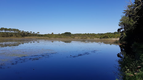
Étang d'Abesse on the map, Saint-Paul-lès-Dax, France
Photo
Where is located Étang d'Abesse
Étang d'Abesse — local attraction, which is located at no data and belongs to the category — -. Average visitor rating for this place — 4.5 (according to 15 ratings, information from open sources and relevant for 2022).
Exact location — Étang d'Abesse, marked on the map with a red marker.
You can get directions to Étang d'Abesse on the map from your location.
What else is interesting in Saint-Paul-lès-Dax? You can see all the sights if you go to the city page.
Coordinates
Étang d'Abesse, France coordinates in decimal format: latitude — 43.75427800606134, longitude — -1.1006623749495386. When converted to degrees, minutes, seconds Étang d'Abesse has the following coordinates: 43°45′15.4 north latitude and -1°6′2.38 east longitude.
Nearby cities
The largest cities that are located nearby:
- San Sebastián
 (Spain) — 87 km
 - Pamplona (Spain) — 112 km
- Bordeaux — 128 km
- Bilbao (Spain) — 160 km
- Vitoria-Gasteiz (Spain) — 163 km
- Logroño (Spain) — 180 km
- Toulouse — 200 km
- Santander (Spain) — 223 km
- Zaragoza (Spain) — 230 km
- Burgos (Spain) — 265 km
- Lleida (Spain) — 271 km
- Limoges — 293 km
- Perpignan — 341 km
- Tarragona (Spain) — 346 km
- Terrassa (Spain) — 348 km
- Sabadell (Spain) — 356 km
- Santa Coloma de Gramenet (Spain) — 370 km
- Gijón (Spain) — 370 km
- L'Hospitalet de Llobregat (Spain) — 370 km
Distance to the capital
Distance to the capital (Paris) is about — 626 km.