
 Maureville
Samoëns
Gréning
Toulouse
Volx
Goudet
Méhoncourt
Saint-Hymer
Pontcarré
Maureville
Samoëns
Gréning
Toulouse
Volx
Goudet
Méhoncourt
Saint-Hymer
Pontcarré
Basilique Saint-Julien on the map, Saint-Pierre-des-Corps, France
Photo
Where is located Basilique Saint-Julien
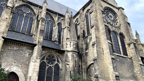
Basilique Saint-Julien — local attraction, which is located at 20 Rue Nationale, 37000 Tours, France and belongs to the category — catholic church. Average visitor rating for this place — 4.6 (according to 562 ratings, information from open sources and relevant for 2022).
Exact location — Basilique Saint-Julien, marked on the map with a red marker.
You can get directions to Basilique Saint-Julien on the map from your location.
What else is interesting in Saint-Pierre-des-Corps? You can see all the sights if you go to the city page.
Coordinates
Basilique Saint-Julien, France coordinates in decimal format: latitude — 47.395827497183106, longitude — 0.6873849251726324. When converted to degrees, minutes, seconds Basilique Saint-Julien has the following coordinates: 47°23′44.98 north latitude and 0°41′14.59 east longitude.
Nearby cities
The largest cities that are located nearby:
- Tours — 3 km
- Le Mans — 78 km
- Angers — 97 km
- Orléans — 105 km
- Nantes — 172 km
- Limoges — 177 km
- Rennes — 195 km
- Boulogne-Billancourt — 195 km
- Caen — 213 km
- Rouen — 229 km
- Le Havre — 237 km
- Clermont-Ferrand — 255 km
- Amiens — 299 km
- Bordeaux — 300 km
- Reims — 316 km
- Dijon — 324 km
- Saint-Étienne — 357 km
- Lyon — 365 km
- Villeurbanne — 368 km
Distance to the capital
Distance to the capital (Paris) is about — 204 km.