
 Maureville
Samoëns
Gréning
Toulouse
Volx
Goudet
Méhoncourt
Saint-Hymer
Pontcarré
Maureville
Samoëns
Gréning
Toulouse
Volx
Goudet
Méhoncourt
Saint-Hymer
Pontcarré
Étang des Trois Sources on the map, L'Isle-Adam, France
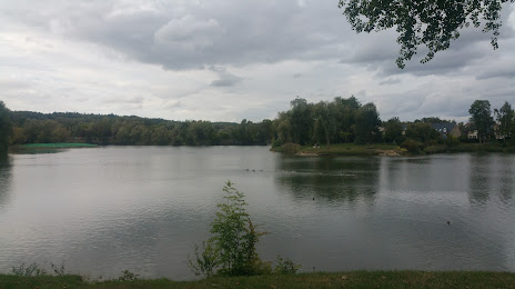
Photo
Where is located Étang des Trois Sources
Étang des Trois Sources — local attraction, which is located at no data and belongs to the category — -. Average visitor rating for this place — 4.5 (according to 16 ratings, information from open sources and relevant for 2022).
Exact location — Étang des Trois Sources, marked on the map with a red marker.
You can get directions to Étang des Trois Sources on the map from your location.
What else is interesting in L'Isle-Adam? You can see all the sights if you go to the city page.
Coordinates
Étang des Trois Sources, France coordinates in decimal format: latitude — 49.12257538297517, longitude — 2.231552675233187. When converted to degrees, minutes, seconds Étang des Trois Sources has the following coordinates: 49°7′21.27 north latitude and 2°13′53.59 east longitude.
Nearby cities
The largest cities that are located nearby:
- Boulogne-Billancourt — 30 km
- Amiens — 87 km
- Rouen — 88 km
- Reims — 132 km
- Orléans — 136 km
- Le Havre — 157 km
- Lille — 178 km
- Caen — 187 km
- Le Mans — 193 km
- Charleroi
 (Belgium) — 213 km
 - Tours — 222 km
- Eastbourne
 (United Kingdom) — 227 km
 - Namur (Belgium) — 239 km
- Brussels (Belgium) — 243 km
- Angers — 275 km
- Gillingham (United Kingdom) — 276 km
- Crawley (United Kingdom) — 277 km
- Antwerp (Belgium) — 278 km
- Metz — 286 km
Distance to the capital
Distance to the capital (Paris) is about — 31 km.