
 Maureville
Samoëns
Gréning
Toulouse
Volx
Goudet
Méhoncourt
Saint-Hymer
Pontcarré
Maureville
Samoëns
Gréning
Toulouse
Volx
Goudet
Méhoncourt
Saint-Hymer
Pontcarré
Parc Pasteur on the map, Saint-Jean-de-Braye, France
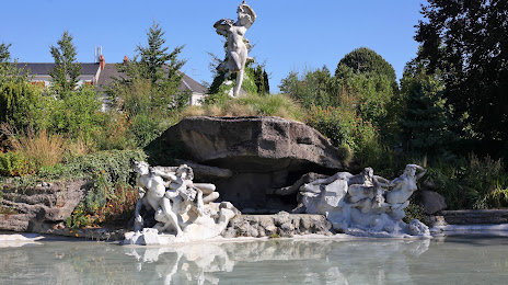
Photo
Where is located Parc Pasteur
Parc Pasteur — local attraction, which is located at 10 Rue Pierre Premier de Serbie, 45000 Orléans, France and belongs to the category — park. Average visitor rating for this place — 4.4 (according to 1911 ratings, information from open sources and relevant for 2022).
Exact location — Parc Pasteur, marked on the map with a red marker.
You can get directions to Parc Pasteur on the map from your location.
What else is interesting in Saint-Jean-de-Braye? You can see all the sights if you go to the city page.
Coordinates
Parc Pasteur, France coordinates in decimal format: latitude — 47.906667065347214, longitude — 1.9109472251903867. When converted to degrees, minutes, seconds Parc Pasteur has the following coordinates: 47°54′24 north latitude and 1°54′39.41 east longitude.
Nearby cities
The largest cities that are located nearby:
- Orléans — 5 km
- Boulogne-Billancourt — 104 km
- Tours — 112 km
- Le Mans — 131 km
- Rouen — 180 km
- Angers — 195 km
- Reims — 210 km
- Caen — 220 km
- Le Havre — 220 km
- Amiens — 220 km
- Limoges — 236 km
- Dijon — 239 km
- Clermont-Ferrand — 251 km
- Rennes — 270 km
- Nantes — 276 km
- Lille — 310 km
- Besançon — 313 km
- Nancy — 319 km
- Lyon — 324 km
Distance to the capital
Distance to the capital (Paris) is about — 111 km.