
 Maureville
Samoëns
Gréning
Toulouse
Volx
Goudet
Méhoncourt
Saint-Hymer
Pontcarré
Maureville
Samoëns
Gréning
Toulouse
Volx
Goudet
Méhoncourt
Saint-Hymer
Pontcarré
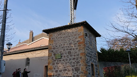
Sainte-Foy-lès-Lyon semaphore tower on the map, Sainte-Foy-lès-Lyon, France
Photo
Where is located Sainte-Foy-lès-Lyon semaphore tower
Sainte-Foy-lès-Lyon semaphore tower — local attraction, which is located at 2 Mnt de la Chapelle, 69110 Sainte-Foy-lès-Lyon, France and belongs to the category — museum. Average visitor rating for this place — 4.0 (according to 15 ratings, information from open sources and relevant for 2022).
Exact location — Sainte-Foy-lès-Lyon semaphore tower, marked on the map with a red marker.
You can get directions to Sainte-Foy-lès-Lyon semaphore tower on the map from your location.
What else is interesting in Sainte-Foy-lès-Lyon? You can see all the sights if you go to the city page.
Coordinates
Sainte-Foy-lès-Lyon semaphore tower, France coordinates in decimal format: latitude — 45.735111780973284, longitude — 4.802137125115969. When converted to degrees, minutes, seconds Sainte-Foy-lès-Lyon semaphore tower has the following coordinates: 45°44′6.4 north latitude and 4°48′7.69 east longitude.
Nearby cities
The largest cities that are located nearby:
- Lyon — 4 km
- Villeurbanne — 8 km
- Saint-Étienne — 46 km
- Grenoble — 94 km
- Geneva
 (Switzerland) — 114 km
 - Clermont-Ferrand — 133 km
- Lausanne (Switzerland) — 164 km
- Dijon — 176 km
- Besançon — 190 km
- Nimes — 213 km
- Turin
 (Italy) — 237 km
 - Bern (Switzerland) — 240 km
- Montpellier — 246 km
- Aix-en-Provence — 249 km
- Limoges — 273 km
- Marseille — 273 km
- Basel (Switzerland) — 291 km
- Mulhouse — 292 km
- Nice — 298 km
Distance to the capital
Distance to the capital (Paris) is about — 393 km.