
 Maureville
Samoëns
Gréning
Toulouse
Volx
Goudet
Méhoncourt
Saint-Hymer
Pontcarré
Maureville
Samoëns
Gréning
Toulouse
Volx
Goudet
Méhoncourt
Saint-Hymer
Pontcarré
Aqualand Saint-Cyr-Sur-Mer on the map, Saint-Cyr-sur-Mer, France
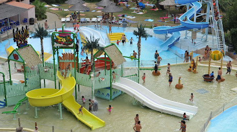
Photo
Where is located Aqualand Saint-Cyr-Sur-Mer
Aqualand Saint-Cyr-Sur-Mer — local attraction, which is located at Zac des, Pradeaux, 83270 Saint-Cyr-sur-Mer, France and belongs to the category — water park. Average visitor rating for this place — 3.6 (according to 3585 ratings, information from open sources and relevant for 2022).
Exact location — Aqualand Saint-Cyr-Sur-Mer, marked on the map with a red marker.
You can get directions to Aqualand Saint-Cyr-Sur-Mer on the map from your location.
What else is interesting in Saint-Cyr-sur-Mer? You can see all the sights if you go to the city page.
Coordinates
Aqualand Saint-Cyr-Sur-Mer, France coordinates in decimal format: latitude — 43.169396269237254, longitude — 5.704454530508596. When converted to degrees, minutes, seconds Aqualand Saint-Cyr-Sur-Mer has the following coordinates: 43°10′9.83 north latitude and 5°42′16.04 east longitude.
Nearby cities
The largest cities that are located nearby:
- Toulon — 19 km
- Marseille — 30 km
- Aix-en-Provence — 44 km
- Nimes — 130 km
- Nice — 137 km
- Montpellier — 154 km
- Grenoble — 222 km
- Perpignan — 235 km
- Turin
 (Italy) — 260 km
 - Saint-Étienne — 270 km
- Genoa (Italy) — 289 km
- Villeurbanne — 293 km
- Lyon — 293 km
- Mataró
 (Spain) — 326 km
 - Geneva
 (Switzerland) — 335 km
 - Novara (Italy) — 337 km
- Toulouse — 345 km
- Badalona (Spain) — 345 km
- Santa Coloma de Gramenet (Spain) — 348 km
Distance to the capital
Distance to the capital (Paris) is about — 683 km.