
 Maureville
Samoëns
Gréning
Toulouse
Volx
Goudet
Méhoncourt
Saint-Hymer
Pontcarré
Maureville
Samoëns
Gréning
Toulouse
Volx
Goudet
Méhoncourt
Saint-Hymer
Pontcarré
Plage du Grand Boucharel on the map, Roquebrune-sur-Argens, France
Photo
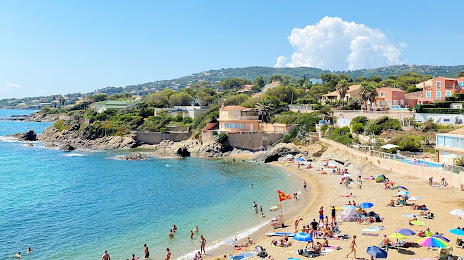
Where is located Plage du Grand Boucharel
Plage du Grand Boucharel — local attraction, which is located at no data and belongs to the category — -. Average visitor rating for this place — 4.5 (according to 27 ratings, information from open sources and relevant for 2022).
Exact location — Plage du Grand Boucharel, marked on the map with a red marker.
You can get directions to Plage du Grand Boucharel on the map from your location.
What else is interesting in Roquebrune-sur-Argens? You can see all the sights if you go to the city page.
Coordinates
Plage du Grand Boucharel, France coordinates in decimal format: latitude — 43.37207635496096, longitude — 6.713663890911615. When converted to degrees, minutes, seconds Plage du Grand Boucharel has the following coordinates: 43°22′19.47 north latitude and 6°42′49.19 east longitude.
Nearby cities
The largest cities that are located nearby:
- Nice — 58 km
- Toulon — 67 km
- Aix-en-Provence — 96 km
- Marseille — 103 km
- Nimes — 187 km
- Turin
 (Italy) — 198 km
 - Grenoble — 206 km
- Genoa (Italy) — 211 km
- Montpellier — 222 km
- Novara (Italy) — 270 km
- Saint-Étienne — 281 km
- Villeurbanne — 291 km
- Lyon — 292 km
- Livorno (Italy) — 295 km
- Milan (Italy) — 298 km
- Geneva
 (Switzerland) — 307 km
 - Monza (Italy) — 313 km
- Perpignan — 315 km
- Parma (Italy) — 326 km
Distance to the capital
Distance to the capital (Paris) is about — 696 km.