
 Maureville
Samoëns
Gréning
Toulouse
Volx
Goudet
Méhoncourt
Saint-Hymer
Pontcarré
Maureville
Samoëns
Gréning
Toulouse
Volx
Goudet
Méhoncourt
Saint-Hymer
Pontcarré
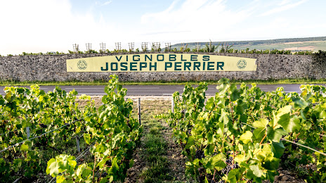
Champagne Joseph Perrier (Champagne & caves JOSEPH PERRIER) on the map, Châlons-en-Champagne, France
Photo
Where is located Champagne Joseph Perrier (Champagne & caves JOSEPH PERRIER)
Champagne Joseph Perrier (Champagne & caves JOSEPH PERRIER) — local attraction, which is located at 69 Av. de Paris, 51000 Châlons-en-Champagne, France and belongs to the category — vineyard. Average visitor rating for this place — 4.7 (according to 78 ratings, information from open sources and relevant for 2022).
Exact location — Champagne Joseph Perrier (Champagne & caves JOSEPH PERRIER), marked on the map with a red marker.
You can get directions to Champagne Joseph Perrier (Champagne & caves JOSEPH PERRIER) on the map from your location.
What else is interesting in Châlons-en-Champagne? You can see all the sights if you go to the city page.
Coordinates
Champagne Joseph Perrier (Champagne & caves JOSEPH PERRIER), France coordinates in decimal format: latitude — 48.952470974718466, longitude — 4.344048725227152. When converted to degrees, minutes, seconds Champagne Joseph Perrier (Champagne & caves JOSEPH PERRIER) has the following coordinates: 48°57′8.9 north latitude and 4°20′38.58 east longitude.
Nearby cities
The largest cities that are located nearby:
- Reims — 41 km
- Metz — 132 km
- Nancy — 136 km
- Boulogne-Billancourt — 155 km
- Charleroi
 (Belgium) — 161 km
 - Namur (Belgium) — 171 km
- Amiens — 180 km
- Trier
 (Germany) — 185 km
 - Dijon — 188 km
- Saarbrücken (Germany) — 193 km
- Liège (Belgium) — 204 km
- Lille — 206 km
- Brussels (Belgium) — 209 km
- Orléans — 216 km
- Besançon — 227 km
- Maastricht
 (Netherlands) — 229 km
 - Aachen (Germany) — 234 km
- Rouen — 241 km
- Antwerp (Belgium) — 250 km
Distance to the capital
Distance to the capital (Paris) is about — 146 km.