
 Maureville
Samoëns
Gréning
Toulouse
Volx
Goudet
Méhoncourt
Saint-Hymer
Pontcarré
Maureville
Samoëns
Gréning
Toulouse
Volx
Goudet
Méhoncourt
Saint-Hymer
Pontcarré
Pagode Tinh Tam on the map, Ville-d'Avray, France
Photo
Where is located Pagode Tinh Tam
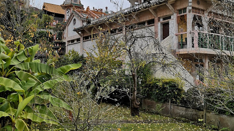
Pagode Tinh Tam — local attraction, which is located at 2 Rue des Bois, 92310 Sèvres, France and belongs to the category — buddhist temple. Average visitor rating for this place — 5.0 (according to 6 ratings, information from open sources and relevant for 2022).
Exact location — Pagode Tinh Tam, marked on the map with a red marker.
You can get directions to Pagode Tinh Tam on the map from your location.
What else is interesting in Ville-d'Avray? You can see all the sights if you go to the city page.
Coordinates
Pagode Tinh Tam, France coordinates in decimal format: latitude — 48.82141579150428, longitude — 2.206666625222481. When converted to degrees, minutes, seconds Pagode Tinh Tam has the following coordinates: 48°49′17.1 north latitude and 2°12′24 east longitude.
Nearby cities
The largest cities that are located nearby:
- Boulogne-Billancourt — 4 km
- Rouen — 104 km
- Orléans — 104 km
- Amiens — 118 km
- Reims — 141 km
- Le Havre — 167 km
- Le Mans — 173 km
- Caen — 189 km
- Tours — 194 km
- Lille — 208 km
- Charleroi
 (Belgium) — 236 km
 - Eastbourne
 (United Kingdom) — 252 km
 - Angers — 254 km
- Namur (Belgium) — 262 km
- Brussels (Belgium) — 270 km
- Dijon — 271 km
- Metz — 290 km
- Nancy — 292 km
- Rennes — 296 km
Distance to the capital
Distance to the capital (Paris) is about — 11 km.