
 Maureville
Samoëns
Gréning
Toulouse
Volx
Goudet
Méhoncourt
Saint-Hymer
Pontcarré
Maureville
Samoëns
Gréning
Toulouse
Volx
Goudet
Méhoncourt
Saint-Hymer
Pontcarré
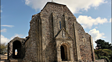
Église Saint-Nicolas de Saint-Nicolas-de-Brem on the map, Les Sables-d'Olonne, France
Photo
Where is located Église Saint-Nicolas de Saint-Nicolas-de-Brem
Église Saint-Nicolas de Saint-Nicolas-de-Brem — local attraction, which is located at 15 Rue du Prieuré, 85470 Brem-sur-Mer, France and belongs to the category — historical landmark. Average visitor rating for this place — 4.5 (according to 58 ratings, information from open sources and relevant for 2022).
Exact location — Église Saint-Nicolas de Saint-Nicolas-de-Brem, marked on the map with a red marker.
You can get directions to Église Saint-Nicolas de Saint-Nicolas-de-Brem on the map from your location.
What else is interesting in Les Sables-d'Olonne? You can see all the sights if you go to the city page.
Coordinates
Église Saint-Nicolas de Saint-Nicolas-de-Brem, France coordinates in decimal format: latitude — 46.61013061292319, longitude — -1.8411066748543787. When converted to degrees, minutes, seconds Église Saint-Nicolas de Saint-Nicolas-de-Brem has the following coordinates: 46°36′36.47 north latitude and -1°50′27.98 east longitude.
Nearby cities
The largest cities that are located nearby:
- Nantes — 82 km
- Angers — 143 km
- Rennes — 180 km
- Bordeaux — 206 km
- Tours — 211 km
- Le Mans — 223 km
- Limoges — 246 km
- Brest — 288 km
- Caen — 315 km
- Orléans — 316 km
- San Sebastián
 (Spain) — 351 km
 - Le Havre — 359 km
- Bilbao (Spain) — 369 km
- Santander (Spain) — 372 km
- Clermont-Ferrand — 385 km
- Rouen — 387 km
- Boulogne-Billancourt — 392 km
- Pamplona (Spain) — 407 km
- Vitoria-Gasteiz (Spain) — 408 km
Distance to the capital
Distance to the capital (Paris) is about — 401 km.