
 Maureville
Samoëns
Gréning
Toulouse
Volx
Goudet
Méhoncourt
Saint-Hymer
Pontcarré
Maureville
Samoëns
Gréning
Toulouse
Volx
Goudet
Méhoncourt
Saint-Hymer
Pontcarré
Centre de découverte du Scamandre on the map, Saint-Gilles, France
Photo
Where is located Centre de découverte du Scamandre
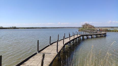
Centre de découverte du Scamandre — local attraction, which is located at Route des Iscles Gallician, 30600 Vauvert, France and belongs to the category — nature preserve. Average visitor rating for this place — 4.6 (according to 708 ratings, information from open sources and relevant for 2022).
Exact location — Centre de découverte du Scamandre, marked on the map with a red marker.
You can get directions to Centre de découverte du Scamandre on the map from your location.
What else is interesting in Saint-Gilles? You can see all the sights if you go to the city page.
Coordinates
Centre de découverte du Scamandre, France coordinates in decimal format: latitude — 43.60567131958437, longitude — 4.337241725045615. When converted to degrees, minutes, seconds Centre de découverte du Scamandre has the following coordinates: 43°36′20.42 north latitude and 4°20′14.07 east longitude.
Nearby cities
The largest cities that are located nearby:
- Nimes — 19 km
- Montpellier — 45 km
- Aix-en-Provence — 83 km
- Marseille — 86 km
- Toulon — 135 km
- Perpignan — 166 km
- Saint-Étienne — 195 km
- Grenoble — 195 km
- Nice — 226 km
- Lyon — 233 km
- Villeurbanne — 234 km
- Toulouse — 239 km
- Clermont-Ferrand — 254 km
- Mataró
 (Spain) — 288 km
 - Turin
 (Italy) — 297 km
 - Sabadell (Spain) — 304 km
- Badalona (Spain) — 306 km
- Geneva
 (Switzerland) — 308 km
 - Terrassa (Spain) — 308 km
Distance to the capital
Distance to the capital (Paris) is about — 604 km.