
 Maureville
Samoëns
Gréning
Toulouse
Volx
Goudet
Méhoncourt
Saint-Hymer
Pontcarré
Maureville
Samoëns
Gréning
Toulouse
Volx
Goudet
Méhoncourt
Saint-Hymer
Pontcarré
Île-Saint-Denis State Park on the map, Saint Denis, France
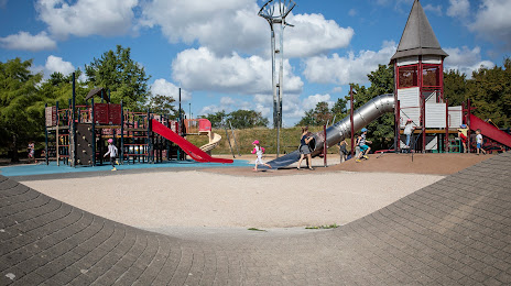
Photo
Where is located Île-Saint-Denis State Park
Île-Saint-Denis State Park — local attraction, which is located at Quai de la Marine, 93450 L'Île-Saint-Denis, France and belongs to the category — city park. Average visitor rating for this place — 4.4 (according to 584 ratings, information from open sources and relevant for 2022).
Exact location — Île-Saint-Denis State Park, marked on the map with a red marker.
You can get directions to Île-Saint-Denis State Park on the map from your location.
What else is interesting in Saint Denis? You can see all the sights if you go to the city page.
Coordinates
Île-Saint-Denis State Park, France coordinates in decimal format: latitude — 48.94941907277865, longitude — 2.3120637252270373. When converted to degrees, minutes, seconds Île-Saint-Denis State Park has the following coordinates: 48°56′57.91 north latitude and 2°18′43.43 east longitude.
Nearby cities
The largest cities that are located nearby:
- Boulogne-Billancourt — 14 km
- Amiens — 106 km
- Rouen — 106 km
- Orléans — 119 km
- Reims — 126 km
- Le Havre — 173 km
- Le Mans — 190 km
- Lille — 194 km
- Caen — 199 km
- Tours — 212 km
- Charleroi
 (Belgium) — 220 km
 - Namur (Belgium) — 245 km
- Eastbourne
 (United Kingdom) — 249 km
 - Brussels (Belgium) — 253 km
- Dijon — 269 km
- Angers — 271 km
- Metz — 277 km
- Nancy — 281 km
- Antwerp (Belgium) — 289 km
Distance to the capital
Distance to the capital (Paris) is about — 11 km.