
 Sanavardo
Undilaantkari
Toncha
Pkhundavi
Tiseli
Ukeshi
Maisauri
Ghogheti
Matsevani
Sanavardo
Undilaantkari
Toncha
Pkhundavi
Tiseli
Ukeshi
Maisauri
Ghogheti
Matsevani
Samshvilde on the map, Bolnisi, Georgia
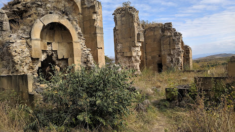
Photo
Where is located Samshvilde
Samshvilde — local attraction, which is located at GF8Q+7JJ, Samshvilde, Georgia and belongs to the category — fortress. Average visitor rating for this place — 4.8 (according to 31 rating, information from open sources and relevant for 2022).
Exact location — Samshvilde, marked on the map with a red marker.
You can get directions to Samshvilde on the map from your location.
What else is interesting in Bolnisi? You can see all the sights if you go to the city page.
Coordinates
Samshvilde, Georgia coordinates in decimal format: latitude — 41.51602421638112, longitude — 44.49036952575626. When converted to degrees, minutes, seconds Samshvilde has the following coordinates: 41°30′57.69 north latitude and 44°29′25.33 east longitude.
Nearby cities
The largest cities that are located nearby:
- Vanadzor
 (Armenia) — 71 km
 - Gyumri (Armenia) — 93 km
- Yerevan (Armenia) — 140 km
- Vladikavkaz
 (Russia) — 173 km
 - Kutaisi — 175 km
- Nazran (Russia) — 196 km
- Nalchik (Russia) — 237 km
- Batumi — 242 km
- Khasavyurt (Russia) — 258 km
- Makhachkala (Russia) — 292 km
- Kislovodsk (Russia) — 309 km
- Pyatigorsk (Russia) — 311 km
- Derbent (Russia) — 315 km
- Khoy
 (Iran) — 322 km
 - Erzurum
 (Turkey) — 326 km
 - Van (Turkey) — 342 km
- Parsabad (Iran) — 349 km
- Marand (Iran) — 351 km
- Cherkessk (Russia) — 364 km
Distance to the capital
Distance to the capital (Tbilisi) is about — 33 km.