
 Norra Grean
Asslebyn
Gillanda
Ödebyn
Håltane
Torp
Tjärtakan
Flicksäter
Dykälla
Norra Grean
Asslebyn
Gillanda
Ödebyn
Håltane
Torp
Tjärtakan
Flicksäter
Dykälla
Kallhäll beach on the map, Jakobsberg, Sweden
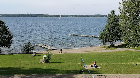
Photo
Where is located Kallhäll beach
Kallhäll beach — local attraction, which is located at Fabriksvägen 20, 176 71 Järfälla, Sweden and belongs to the category — swimming lake. Average visitor rating for this place — 4.0 (according to 577 ratings, information from open sources and relevant for 2022).
Exact location — Kallhäll beach, marked on the map with a red marker.
You can get directions to Kallhäll beach on the map from your location.
What else is interesting in Jakobsberg? You can see all the sights if you go to the city page.
Coordinates
Kallhäll beach, Sweden coordinates in decimal format: latitude — 59.45223501671086, longitude — 17.792736125532127. When converted to degrees, minutes, seconds Kallhäll beach has the following coordinates: 59°27′8.05 north latitude and 17°47′33.85 east longitude.
Nearby cities
The largest cities that are located nearby:
- Stockholm — 17 km
- Uppsala — 49 km
- Västerås — 75 km
- Turku
 (Finland) — 267 km
 - Espoo (Finland) — 385 km
- Tampere (Finland) — 388 km
- Tallinn
 (Estonia) — 389 km
 - Oslo
 (Norway) — 396 km
 - Helsinki (Finland) — 400 km
- Vantaa (Finland) — 406 km
- Klaipėda
 (Lithuania) — 460 km
 - Rīga
 (Latvia) — 467 km
 - Šiauliai (Lithuania) — 514 km
- Malmö — 519 km
- Copenhagen
 (Denmark) — 529 km
 - Tartu (Estonia) — 529 km
- Aalborg (Denmark) — 543 km
- Gdynia
 (Poland) — 544 km
 - Kaliningrad
 (Russia) — 548 km
Distance to the capital
Distance to the capital (Stockholm) is about — 20 km.