
 Bokamoso
Buysdorp
Xihosana
Ga-Sekororo
Ga-Rankuwa
Three Sisters
George
Haenertsburg
Polokwane
Bokamoso
Buysdorp
Xihosana
Ga-Sekororo
Ga-Rankuwa
Three Sisters
George
Haenertsburg
Polokwane
AutoPavilion on the map, Uitenhage, South Africa
Photo
Where is located AutoPavilion
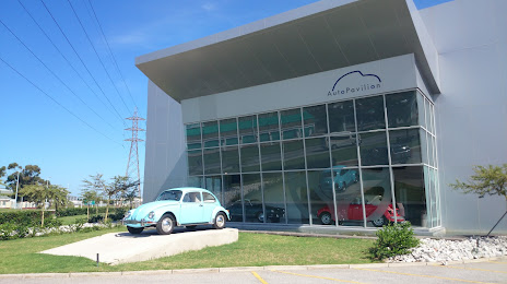
AutoPavilion — local attraction, which is located at 103 Algoa Rd, Alexander Park, Kariega, 6230, South Africa and belongs to the category — museum. Average visitor rating for this place — 4.5 (according to 513 ratings, information from open sources and relevant for 2022).
Exact location — AutoPavilion, marked on the map with a red marker.
You can get directions to AutoPavilion on the map from your location.
What else is interesting in Uitenhage? You can see all the sights if you go to the city page.
Coordinates
AutoPavilion, South Africa coordinates in decimal format: latitude — -33.78485556605734, longitude — 25.420904424662922. When converted to degrees, minutes, seconds AutoPavilion has the following coordinates: -33°47′5.48 north latitude and 25°25′15.26 east longitude.
Nearby cities
The largest cities that are located nearby:
- Port Elizabeth — 27 km
- Bisho — 214 km
- East London — 243 km
- Queenstown — 251 km
- George — 273 km
- Mossel Bay — 304 km
- Botshabelo — 514 km
- Bloemfontein — 520 km
- Maseru
 (Lesotho) — 532 km
 - Worcester — 550 km
- Kimberley — 559 km
- Paarl — 594 km
- Cape Town — 642 km
- Virginia — 642 km
- Welkom — 652 km
- Pietermaritzburg — 663 km
- Durban — 690 km
- Kroonstad — 700 km
- Orkney — 761 km
Distance to the capital
Distance to the capital (Pretoria) is about — 933 km.