
 Gilserberg
Berlin
Bordesholm
Bechtolsheim
Aub
Triptis
Heppenheim
Biblis
Angermünde
Gilserberg
Berlin
Bordesholm
Bechtolsheim
Aub
Triptis
Heppenheim
Biblis
Angermünde
Waldkloster Muttodaya on the map, Münchberg, Germany
Photo
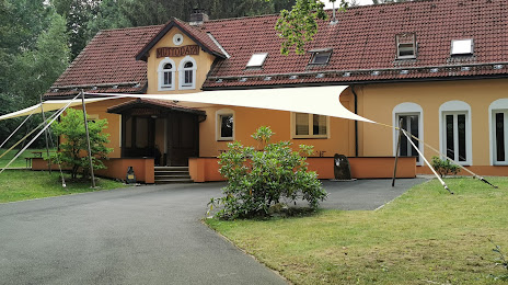
Where is located Waldkloster Muttodaya
Waldkloster Muttodaya — local attraction, which is located at 95236 Stammbach, Germany and belongs to the category — buddhist temple. Average visitor rating for this place — 4.6 (according to 35 ratings, information from open sources and relevant for 2022).
Exact location — Waldkloster Muttodaya, marked on the map with a red marker.
You can get directions to Waldkloster Muttodaya on the map from your location.
What else is interesting in Münchberg? You can see all the sights if you go to the city page.
Coordinates
Waldkloster Muttodaya, Germany coordinates in decimal format: latitude — 50.12910219031337, longitude — 11.645531925174609. When converted to degrees, minutes, seconds Waldkloster Muttodaya has the following coordinates: 50°7′44.77 north latitude and 11°38′43.91 east longitude.
Nearby cities
The largest cities that are located nearby:
- Gera — 79 km
- Erlangen — 87 km
- Nuremberg — 96 km
- Fürth — 98 km
- Erfurt — 103 km
- Chemnitz — 106 km
- Pilsen
 (Czech Republic) — 124 km
 - Regensburg — 132 km
- Leipzig — 133 km
- Würzburg — 138 km
- Ingolstadt — 160 km
- Dresden — 165 km
- Prague (Czech Republic) — 188 km
- Göttingen — 197 km
- Kassel — 202 km
- Augsburg — 212 km
- Magdeburg — 214 km
- Offenbach — 214 km
- Heilbronn — 220 km
Distance to the capital
Distance to the capital (Berlin) is about — 293 km.