 Warner Robins
Wantagh
Bethel
Misty Hill Farm
United States
Wakonda Beach (R33) Airport
Wilmington
Poland
Miami International Airport
Warner Robins
Wantagh
Bethel
Misty Hill Farm
United States
Wakonda Beach (R33) Airport
Wilmington
Poland
Miami International Airport
Four Rivers Cultural Center & Museum on the map, Ontario, United States
Photo
Where is located Four Rivers Cultural Center & Museum
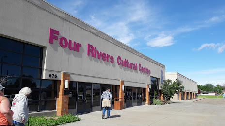
Four Rivers Cultural Center & Museum — local attraction, which is located at 676 SW 5th Ave, Ontario, OR 97914, United States and belongs to the category — cultural center. Average visitor rating for this place — 4.5 (according to 336 ratings, information from open sources and relevant for 2022).
Exact location — Four Rivers Cultural Center & Museum, marked on the map with a red marker.
You can get directions to Four Rivers Cultural Center & Museum on the map from your location.
What else is interesting in Ontario? You can see all the sights if you go to the city page.
Coordinates
Four Rivers Cultural Center & Museum, United States coordinates in decimal format: latitude — 44.02279640555919, longitude — -116.97298237503529. When converted to degrees, minutes, seconds Four Rivers Cultural Center & Museum has the following coordinates: 44°1′22.07 north latitude and -116°58′22.74 east longitude.
Nearby cities
The largest cities that are located nearby:
- Boise — 75 km
- Spokane — 403 km
- Portland — 473 km
- Vancouver — 475 km
- Salem — 486 km
- Eugene — 487 km
- Tacoma — 544 km
- Reno — 553 km
- West Valley City — 556 km
- Bellevue — 556 km
- Salt Lake City — 557 km
- Seattle — 563 km
- West Jordan — 566 km
- Provo — 613 km
- Kelowna
 (Canada) — 673 km
 - Victoria (Canada) — 676 km
- Abbotsford (Canada) — 678 km
- Roseville — 692 km
- Surrey (Canada) — 711 km
Distance to the capital
Distance to the capital (Washington) is about — 3343 km.